**** Info via Environment Canada
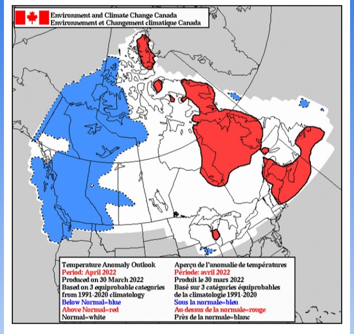
April Temperature Outlook via Environment Canada
The beginning of March continued to be cold in the Prairies. Temperatures ran 6 to 16 degrees below normal in southern Alberta, Saskatchewan and Manitoba from March 2 to March 11. About 10 – 20 cm of snow also fell during the same first week. Meanwhile, Atlantic Canada was blasted with winds gusting 80-130 km/h, rain and snow as an intense storm tracked across New Brunswick March 12 before crossing southeastern Labrador on March 13. Cartwright, NL even set a new record for the lowest observed barometric pressure at the site, bottoming out at 945.1 mb, breaking the previous record of 950.7 mb set in 1972. Most of Canada had a taste of spring between March 15 and March 22, as above-normal temperatures occurred every day. Yet, another push of cold air took place during the last week of March for Manitoba, northwestern Ontario and eventually Quebec, slowing the spring melting.
Here is the forecast for the “temperature anomaly” for the month of April. The temperature anomaly is the “difference from normal temperatures” for the entire month.
The forecasts are categorized as:
- blue indicates below normal temperatures;
- white (no colour) indicates near normal temperatures; and
- red indicates above normal temperatures – all categories are compared to the 30 seasons of the 1991-2020 period.

This is a prediction of the anomaly of the mean daily temperature at 2 metres (i.e. at standard temperature observation height). It is not a forecast of the maximum nor of the minimum daily temperature.


