
**** Info via Environment Canada
October Temperature Outlook
The last full day of summer on September 21 was hot in Labrador with many records falling, including at Happy Valley-Goose Bay where the mercury climbed to 27.7 °C, and beat the old record of 26.7 °C set in 1946.
Meanwhile a slow-moving cold front was responsible for bringing significant rain, flooding and strong winds to southern Ontario and southeastern Quebec for the start of fall. London Airport, ON received 120 mm of rain between the 21st and 23rd of September, Algonquin Park (East Gate), ON saw 104 mm and the Upper Laurentians, in Quebec got between 50 to 100 mm. Over the same time, Sarnia Airport, ON had a peak wind gust of 93 km/h.
Finally, September finished up hot in southern Saskatchewan and Manitoba with many locations exceeding 30 °C, including Regina, which hit 33.3 °C on the 28th, breaking the old record of 32.2 °C set in 1898 and Winnipeg, which hit 31.5 °C on the 29th, beating the old record of 30.0 °C set in 1905.
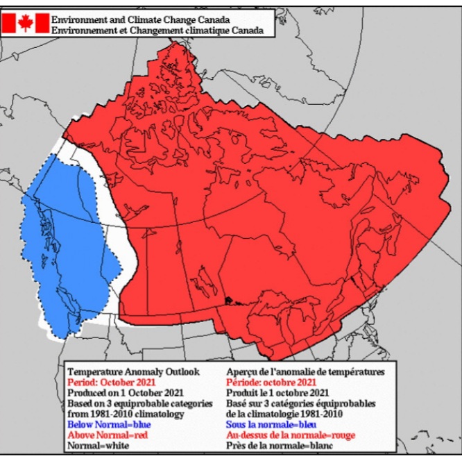
Here is the forecast for the “temperature anomaly” for the month of October. The temperature anomaly is the “difference from normal temperatures” for the entire month.
The forecasts are categorized as:
- blue indicates below normal temperatures;
- white (no colour) indicates near normal temperatures; and
- red indicates above normal temperatures – all categories are compared to the 30 seasons of the 1981-2010 period.

This is a prediction of the anomaly of the mean daily temperature at 2 metres (i.e. at standard temperature observation height). It is not a forecast of the maximum nor of the minimum daily temperature.


