**** Info via Environment Canada
Significant weather events in 2022
Top 10 Weather Events in 2022
1. Furious Fiona strikes Eastern Canada
A remarkably slow and quiet beginning to Atlantic hurricane season changed dramatically during the final week of September with the arrival of two blockbuster historic hurricanes: billion-dollar Fiona in Canada and Ian in the United States.
Fiona began as a tropical depression on September 14 over the warm waters of the central Caribbean. As a Category 1 hurricane, Fiona brought torrential rains, flash flooding and powerful winds to Puerto Rico and the Dominican Republic before strengthening to Category 3 and becoming the first major hurricane of the season. East of the Bahamas, Fiona reached Category 4. Twelve days later and 4 000 km away, Fiona finally dissipated in the Labrador Sea over much cooler waters, after leaving a path of destruction all the way from the Virgin Islands to Eastern Canada.
On September 22, a separate mid-latitude storm stretching from Hudson Bay to Labrador brought wet weather. At the same time, Fiona grew larger, with its strong winds and heavy rains spreading well away from the storm’s centre to an expansive 800 km diameter. Over the next two days, the storms quickly merged into an extremely powerful post-tropical system with characteristics of both a strong hurricane and a strong fall cyclone.
Although Fiona morphed into a post-tropical system before landfall, the storm lost little of its strength by the time it arrived in Canada. During the early morning hours of September 24, Fiona made landfall in eastern Nova Scotia with sustained winds of 165 km/h at hurricane-force 2. It arrived with a minimum pressure of 932.7 millibars near the eye, the deepest barometric pressure for a storm ever recorded over land in Canada. The reading smashed Canada’s previous all-time sea-level pressure record at 940.2 millibars from 1977 and was on par with past violent hurricanes such as Sandy and Andrew.
The storm continued north across Cape Breton during the pre-dawn hours of September 24 and then over the cooler waters of the Eastern Gulf of St. Lawrence to southwest Newfoundland during the day. The storm finally reached Quebec’s Lower North Shore early on September 25 before racing across southeastern Labrador and spinning out over the Labrador Sea later that day.
Fiona pounded Atlantic Canada with heavy rains, powerful winds, mighty storm surges and incredibly high waves. Rainfall of 80 to 150 mm or more occurred across the Maritimes and eastern Quebec. At its peak, the storm’s rainfall rates exceeded 30 mm per hour, triggering flash flooding with ponding and washouts. Fast-moving waters flooded everywhere, filling basements, collapsing roads, overwhelming culverts, triggering landslides, slumping soil, and eroding road beds.
Significant storm surges reaching nearly two metres caused extensive coastal damage and erosion, particularly on the beaches at Prince Edward Island’s Cavendish-North Rustico, Brackley-Dalvay and Greenwich, in the Northumberland Strait and on parts of Cape Breton’s east coast, Mainland Nova Scotia and southwestern Newfoundland. Giant walls of water came ashore, causing significant coastal erosion that will take decades to heal. A buoy over Banquereau Bank (east of Cape Breton) recorded waves averaging 12 to 15 metres, with peak waves reaching an astonishing 30 metres.
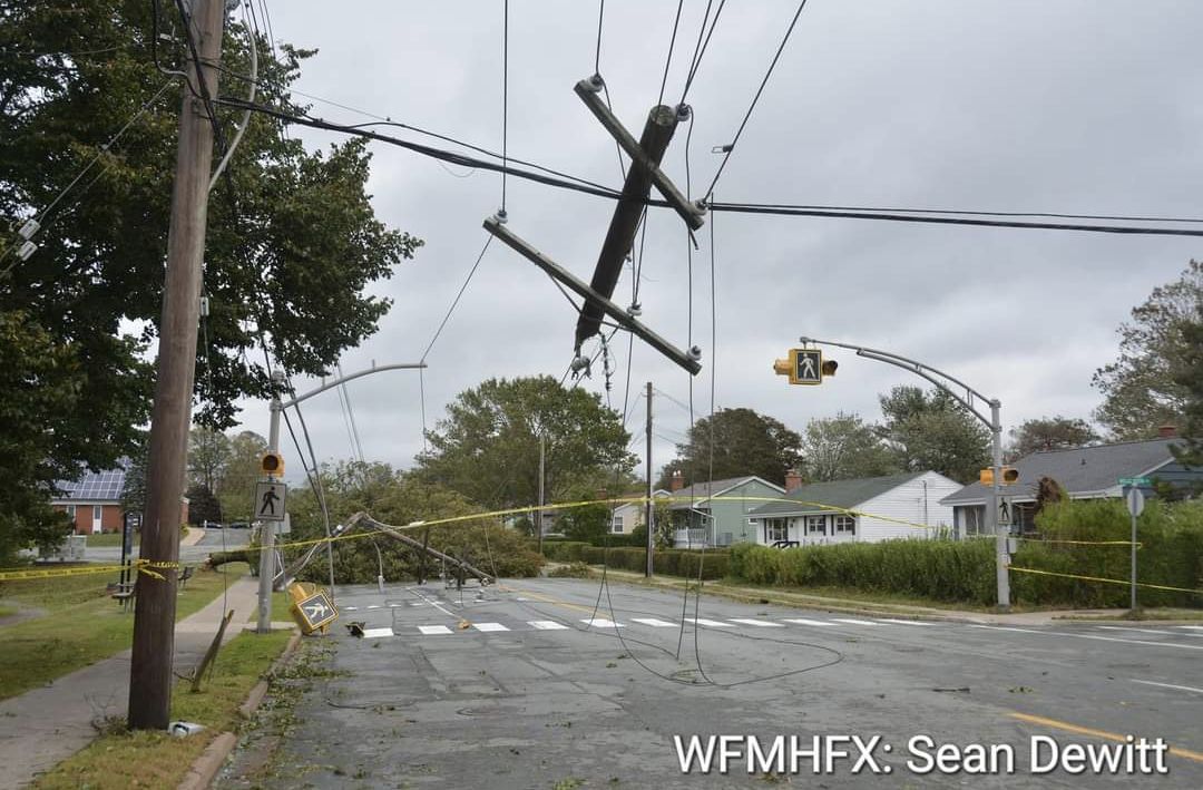
Fiona’s strongest winds of 179 km/h were felt along Nova Scotia’s North Shore, and the western and southwestern parts of Newfoundland and Labrador topped 177 km/hour in the Wreckhouse area. Wind gusts exceeding 100 km/h occurred in five provinces and lasted 6 to 12 consecutive hours. Fully leafed trees created added stress and soft ground from previous rains made trees easy marks for storm winds. Power poles and century-old trees toppled like dominos, while relentless winds and the powerful storm surge damaged and destroyed homes and buildings, transforming coastal geography. Fiona left streets, beaches and parks littered with downed branches and foliage. There were structural losses and considerable coastal infrastructure damage to wharves, piers and breakwaters. Strong winds ripped roofs from homes in some areas. Fiona’s fury also claimed several natural tourism landmarks such as heritage trees, rock formations, statues and popular geographic features.
In Quebec, the Magdalen Islands were the hardest hit: peak wind gusts reached 132 km/h. The Island faced 37 evacuations, closed roads and declared a state of emergency. On September 25, the eastern end of Anticosti Island as well as the Lower Shore of Québec from Minganie to Blanc-Sablon were soaked with 80 mm rains, lashed by winds of 100 km/h and pounded by 10 metre waves. Homes, cottages and boats were damaged and trees uprooted; in some cases, cottages and outbuildings were blown off their foundations.
Utility workers in Atlantic Canada, aided by crews from Ontario, Quebec and Maine, faced the herculean undertaking of repairing electrical transmission and distribution systems. Falling trees knocked out power to more than 600 000 homes and businesses, some having to endure outages for more than two weeks. The impacts were large and immediate and it will take months if not years to clean up and restore infrastructure over five provinces. Nearly 1000 soldiers and military engineers of the Canadian Armed Forces moved in to help start the process.
Thanks to particularly accurate long-range forecasts and warning, residents were able to prepare for the storm by tying down outdoor furniture and stocking up on groceries, flashlights and batteries while work crews cleared culverts and catch basins.
Fiona was a large-scale, high-impact storm and likely the most damaging hurricane in Canadian history. Tragically, there were three storm-related deaths associated with the storm. Fiona’s unusually slow forward speed contributed greatly to the destruction. To date, insurance losses come in at $846 million.

2. Billion-dollar derecho rakes across Ontario and Quebec
Just before the May long weekend, two days of intense heat and humidity propelled a hugely powerful line of storms across central Ontario and Quebec, bringing torrential rains, large hail and frequent lightning. However, it was the swath of downburst winds that resulted in the most damage. Meteorologists call this kind of system a derecho – a group of thunderstorms that move in a straight line much like the frontline of advancing soldiers in a battlefield. Derechos can cause as much damage as a hurricane or tornado but usually cover a larger area than a tornado.
For the first time in Environment and Climate Change Canada’s weather service’s history, it issued a broadcast immediate severe thunderstorm alert through the National Public Alerting System (Alert Ready), as a means of directly reaching those close to the affected region through their mobile devices, radios and televisions. These alerts are issued only when an observed thunderstorm meets the criteria for a life-threatening storm. People were urged to take immediate shelter.
Around noon on May 21, the skies turned from bright and sunny to dark and foreboding. The storm cluster moved quickly, traversing 1 000 km from Sarnia to Quebec City in nine hours with damage over 100 km wide. Strong upper-level winds blew down into the storm’s centre, pushing horizontal straight-line winds forward.
Embedded at the leading edge of the system was a tornado that touched down in Uxbridge with a maximum wind speed of 195 km/h. Two other tornadoes were documented south of London. One intense downburst in south Ottawa had velocities of 190 km/h.
Whereas Ontario and Quebec have seen derechos before, this was one of the few in memory that raced through major cities. The derecho travelled along the Highway 401 corridor through Ottawa before crossing into Quebec. Montreal was mainly spared as the storm moved east from Ottawa and north of the St. Lawrence River towards Trois-Rivières, Quebec City and the Eastern Townships.
Winds broke branches and sometimes yanked entire trees out of the ground, exposing their roots. Winds easily took out entire lines of trees, blocking roads and slowing traffic. Hundreds of thousands of majestic, mature shade trees, some 100-years-old, were lost to the storm. Winds turned loose objects into flying projectiles, overturned vehicles, tore down construction scaffolding and ripped shingles off roofs. Countless homes and porches were cracked, bent and broken by falling trees.
Passengers on trains, airlines and transit services faced hours-long delays due to downed power lines and live wires across roads and tracks. In rural areas, winds flattened 100-year-old barns, took down silos, tossed around farm equipment and flattened early crops. More than a million hydro customers across Ontario and Quebec were left without power. A week later power was still out for nearly 30 000 homes. Ottawa Hydro claimed the damage and disruption to the hydro system was worse than the ice storm of January 1998 and the swarm of tornadoes in September 2018.
Tragically, 11 people died in the aftermath, mostly by fallen trees. At least 13 communities declared states of emergency, including the towns of Uxbridge and Clarence-Rockland, east of Ottawa. The storm resulted in more than a million insurance claims, topping one billion dollars in damages, making it the sixth largest in terms of insured losses in Canadian history.
3. Manitoba’s drenching spring
At the midway point of the 2022 flood season, flow along the Red River in southern Manitoba didn’t appear to be a threat. However, by May 1, following a parade of five wet Colorado low systems, Manitoba faced some of its most extensive, longest-lasting flooding in years. The Pembina, Assiniboine, Souris, Fisher, Roseau, Rat, Winnipeg and Red Rivers were all at risk of overflowing.
Over the winter, most areas of southern Manitoba saw upwards of 150 cm of snow, making it the third-highest snowfall since 1872. In spring, Winnipeg recorded a total of 331.4 mm in precipitation, making it the wettest on record (the previous record of 325.4 mm was set in 1896). It was also 3.6 times the 30-year normal, a quantity unseen since records began in 1872.
Record amounts of snow and rain fell in April and May, streaming in at 30 to 60 mm at a time. Because this happened when most of the ground was still frozen and saturated with water, the soil was unable to absorb the high intensity, short duration rainfall. Strong wind gusts up to 80 km/h only worsened the flooding, causing water levels on lakes and fields to rise and overflow onto roads and erode dikes.
Water levels on the Red River approached those of the 2009 flood, the highest since the 1997 flood of the century. And in 2022, the river crested with its sixth-highest volume since record keeping began.
At the peak of the flooding, 45 municipalities and nine First Nation communities across the province declared local states of emergency due to churned up and washed-out roads, swollen ditches, flooded properties and damage to water treatment infrastructure. Residents everywhere were busy operating water pumps, inspecting dikes and filling sandbags. Floodwaters surrounded entire towns. The province closed provincial parks, campgrounds, and hiking trails. Soggy grounds forced the cancellation of sporting practices, games and tournaments for weeks.
More than 1 000 residents of Peguis First Nation were forced to flee their homes amid severe flooding and an ice jam, the worst since 2000.
Manitoba has a long history of spring flooding, but in 2022, it came from clusters of back-to-back wet days. People dealt with flood fatigue, stress and burnout amid a disaster that dragged on for eight weeks. The geographic scale of this year’s flooding was unprecedented; a result of several high yielding storms, rather than from a single snowmelt or a single storm event like in 1997. While perhaps not the worst in history, the extent and duration of the flood certainly felt historic with flood-related cost estimates nearing $10 million.

4. Return to hot and dry weather under the dome
Summer 2022 was the third warmest Canadian summer on record, eclipsed only by 2012 and 1998. Across the country it was consistently warm – almost 1.6°C above normal. In many places, the summer-like weather stretched over five or six months– from May into October in some, and from July to November in others.
In 2021, it was May to July warmth for western Canada under the infamous heat dome. This year the blocking dome returned to the West from late August to October. In the East, a stationary high pressure kept summer going until mid-November. Many weather sites in the West broke century-long records for the warmest August to October period on record. Because of the abnormally cool, wet spring, farmers were especially grateful for the incredible harvest weather beyond Thanksgiving that helped balance what had been a record late start to the growing season.
In the West
A sprawling and unusually persistent dome over the western half of North America, often referred to a sub-tropical Hawaiian high-pressure ridge, was responsible for the long stretch of record-setting heat across both sides of the border. Excessive heat watches and warnings affected millions of North Americans across three provinces, three territories and eight states. While this high-pressure heat dome was less intense than last year’s prevailing weather, it lasted several weeks longer. The immense area of dryness across western North American contributed to the Northern Hemisphere drought.
From mid-August to mid-October, more than 500 maximum daily temperature records were surpassed over 70 days. British Columbia had one of the hottest Augusts on record. Lytton, where a national all-time high temperature tragically wreaked widespread devastation in 2021, again topped out with a high of 39.6°C on September 2. This was the highest temperature ever observed in British Columbia during the month of September.
Emergency water limits affected heavy commercial water users such as breweries, water bottlers, concrete and cement companies, and cannabis growers. Farm animals and crops suffered as irrigation halted. Drought pushed trees to the edge of dying, causing fears that they would topple in winter windstorms. Limits were imposed on sprinkling gardens and there were widespread bans on filling swimming pools, washing cars and boats. Millions of residents and commercial customers were asked to conserve precious treated drinking water, including by taking shorter showers. The drought and heat challenged BC’s power-generating system and caused issues for managing dwindling water supplies from and into reservoirs.
With temperatures hitting 38°C in the southern part of Alberta and Saskatchewan, August was one of the hottest months on record for the province. The warmth carried over into September, where Medicine Hat recorded a high of 38.3°C on September 3– the community’s hottest September day in the books. Nearby in Swift Current, the temperature soared to 36.4°C, smashing another monthly record. After the third warmest summer in 75 years, Alberta’s fall was dry and smoky. Albertans used to cooler and snowier falls would be likely to think the weather felt much more like June than October.
It wasn’t just hot; it was record dry too. From July 19 to October 19, British Columbia was North America’s dry spot. In Vancouver, only 13 mm of rain fell. This was in contrast to the normal total of 176 mm and 2021’s total of 294 mm for the same timespan. The situation was worse in Victoria, where there was less than 2 mm of rain compared to the normal 120 mm. This made it the driest period for the city since records began in 1898. Renowned dry cities such as Las Vegas, Los Angeles and Phoenix received more rain in these 100 days than Vancouver Island, the Lower Mainland and the Gulf Islands.
The combination of record long heat and dryness had enormous impacts on almost every aspect of the economy and the environment across northern and western Canada. The persistent warmth and dryness kept the wildfire season active up to nine weeks longer than normal. Skies were stale and smoky for 12 weeks beyond the peak of forest fire season. With little or no rain for eight weeks, rivers and streams started drying up. With a dwindling water supply, it became too hot for fish to survive and oxygen depletion led to a massive die-off of thousands of salmon returning to stream along coastal rivers and streams.
The extensive and enduring drought prompted several communities, desperate for rain, to declare states of local emergency, especially on the Sunshine Coast. Adding to the anxiety and unbearable heat, millions of residents and business were forced to conserve drinking water and observe strict restrictions.
In the East
Eastern Canada saw a bonus four weeks of summer warmth, with ample sunshine, light winds and little rain between Thanksgiving and Remembrance Day. In November across the East, more than 200 heat records were set and many daytime highs exceeded 20°C. St. Catharines, ON, St. Anicet, QC, Fredericton, NB and Kentville, NS, all recorded their all-time warmest temperatures for the month. The odd foggy morning couldn’t spoil nature’s gift.
It was another high-pressure ridge known as a Bermuda High, a semi-permanent feature that became established farther north and west than its summer position, that continued to pump southern air northward. In Atlantic Canada, sea-surface temperatures were also 3 to 4 °C warmer than normal.
This was no one- or two-day warm spell, but a glorious four-week stretch that residents could not recall happening before so late in the year. Crowds flocked to parks, waterfronts and golf courses to enjoy September temperatures in November. Nature seemed confused and awakened to growing again. Many Easterners, pleased with the extended summer, hoped that it might mean a shorter than normal winter.

5. Wildfires on two coasts
Canada’s 2022 wildfire season got off to a slow start thanks to a cooler and wetter than usual spring. By July things quickly changed.
The British Columbia wildfire season had a quiet start in part due to a persistently cool, rainy spring and early summer along with a robust snowpack. There was also far less lightning and most strikes that did occur hit snowy mountain ridges with little ignition. An unusual strengthening of the La Niña weather pattern kept water and air temperatures depressed. By June, fires had only burned 5% of the area relative to the 25-year average. Daily firefighting activity was more about bailing and bagging against flood risk than hosing down embers and in-ground “zombie” wildfires.
In mid-July, more than three weeks after summer began, the first major British Columbia wildfire started burning near a place Canadians were only too familiar with: Lytton. Last year, on June 29, after three days of record-breaking Canadian temperature records, 90% of the village tragically burned to the ground. This year’s blaze, named the Nohomin Creek Fire, broke out on July 14 just west of Lytton on the other side of the Fraser River. In the beginning, the winds were not a problem, but fighting flames in steep terrain was a constant challenge. Residents of the nearby Lytton First Nations community suffered heavy losses. By July 27, over 100 people had left their homes and at least 10 structures were destroyed. Smoky skies prompted an air quality advisory when smoke filled the adjacent Stein Valley.
A week later, an air quality advisory was in place for eastern parts of Metro Vancouver and the Fraser Valley as a strong ridge of high pressure began to lock in over the province, with temperatures exceeding 40°C in the interior. Concerns about wildfires were mounting as nearly 4 000 lightning strikes occurred over two days, mostly dotting the southern Interior.
At the end of July, another major blaze, the Keremeos Creek wildfire, broke out in view of Penticton and started leaping across the region. The fire quickly grew under extreme heat and high winds across steep terrain. A day later, the occupants of 375 properties in the village of Olalla and the Apex Mountain resort were ordered to evacuate. In less than a day, the fire tripled in size. Shifting wind patterns kept firefighters guessing and residents in several communities in the southern Okanagan and Fraser were on edge. At the end of July, other fires burning northwest of Kamloops and north of Nelson prompted more evacuation alerts. Hundreds of lightning strikes sparked several new wildfires on Vancouver Island. By August 4, the provincial government had issued 1000 property evacuations, albeit less than in 2021 when 25 000 such orders were in place.
By August 11, welcome rains, lighter winds, higher humidity and more seasonable temperatures quieted the fires. However, things changed in September and October when wildfire smoke from southern British Columbia and Washington State continued to cause hazy skies and smoky conditions over the lower half of the province. An unusually long warm and historic dry fall kept the forest fire threat high with no end in sight until late October.
By October 21, there were over 200 active forest fires burning in the province, five times the average number for that time of the year. In 2022, there were 18 days with air quality advisories in Metro Vancouver, with 12 after mid-September. But, in the end, British Columbia’s wildfire season was well below the average area burned at 1050 km2 compared to the 10-year average of 4232 km2.
By contrast, parts of central Newfoundland experienced the worst wildfires the province had seen in over 60 years. Summer temperatures were warmer by 2 to 3°C and rainfall across the province was consistently 60 to 70% below normal. Conditions were even warmer and drier in central and northeastern parts of the province. Lightning activity was also well above normal, marking the third most active July since records began in 2002. Rivers were bone dry and bogs were drying up.
A rash of lightning storms broke out across central Newfoundland and Labrador during the last week of July. Two fires burned simultaneously and out-of-control: The Paradise Lake fire south of Grand Falls-Windsor, and a second smaller but more impactful fire straddled either side of the Bay d’Espoir highway. Responders feared that both fires might merge.
On August 6, the Government of Newfoundland and Labrador declared a weeklong state of emergency in the region and instituted an open fire ban on forest lands across the central and eastern areas of the province. Water bombers were brought in from Quebec to help fight the fires and the Canadian Armed Forces was on stand-by.
The fires never reached communities, but connecting highways closed intermittently along a stretch of 200 km, stranding residents and those who had returned for “Come Home” year celebrations and festivals. For more than two weeks, hundreds of residents closest to the fires were on pins and needles with the threat of possible evacuation at a moment’s notice. Further, it was difficult to get supplies to some communities and concern continued about excessive smoke continued. Essentials started running low in some of the small communities along the Bay d’Espoir highway.
The shutdown cut off Connaigre Peninsula towns from their main grocery supply route, and store shelves quickly grew bare. Food and supplies had to be flown in by helicopter. Meanwhile, smoke and air quality concerns prompted provincial officials to declare a state of emergency in Grand Falls-Windsor and several surrounding communities. Widespread showers in the second week of August helped quiet the flames. Further, lighter winds calmed the fire behavior and temperatures dropped, helping crews fighting fires.
While 2022’s wildfire season was less severe in British Columbia, residents of Newfoundland felt the widespread impacts of the heat-driven event in ways not seen in decades.

6. A wintery spring in British Columbia (without the flood)
Residents of British Columbia were mostly trying to forget 2021. After all, it was the most destructive, disruptive, expensive and deadliest year for weather, ever. They were hoping for an easy winter to start 2022, but instead got early snow and cold. Spring was the next big hope, but it was winter-like weather up to the first day of summer.
Several communities across the province experienced record-breaking lows over the Easter weekend. Twenty-seven low minimum temperature records were set on April 16, including Vancouver, which registered its coldest day for the month since observations began in 1896. Nanaimo saw its wettest April since 1892. In Victoria, 23 of 30 days were wet between May 20 and June 18. And this was supposed to be the dry season. In Vancouver, no records were set in June, but the numbers were depressing. More rain (40 per cent higher than average with 19 wet days), lower temperatures, and far less sunshine than average (with six days with nary a minute of sunshine), had a June coined Juneuary by locals.
A steady parade of cold lows from the North Pacific Ocean, along with the hangover effects of a two-year long La Nina, were to blame for the dreary weather. With the season weeks behind, it was a tense time for growers and gardeners. Farmers, still reeling from 2021’s heat dome and flooding, were confronted by an unusually challenging spring.
The cold soil temperatures threatened horticulture crops even before the fruit had formed. Fields were too wet to plow or plant. Some orchardists resorted to using helicopters to force the higher, warmer air down toward the fruit tree canopies to inhibit frost. Farm equipment became stuck in the muck. The trees were late to leaf. Gardeners called it the worst spring in 20 years, spending much of their time battling slugs. Honeybees were reluctant to leave their hives to get on with the work of pollinating. Early field crops rotted in the ground. Blueberry bushes were without blossoms and full-blossomed raspberry fields were barren. At harvest, fruit was stunted at half the normal size, and not that sweet.
Ironically, though, there were a few positive outcomes from spring’s misery. The cool and wet weather helped reduce the risk of early wildfires across the province. By June 1, the slow start to wildfire season was evident in that only 600 hectares of forestland had been consumed so far, only 5% of the 25-year average. In addition, the cooler-than-normal spring put off an immediate flood threat, by delaying the spring freshet (thaw) by three or four weeks.
In an average year, about 18% of British Columbia’s mountain snowpack is gone by May 15. In 2022, less than 3% had melted by the end of May. Conversely, as of June 1, mountain snowpack throughout the province was 165% above normal, up from 128% in mid-May. By June 20, mountain snow packs were 200% of normal across the province. River levels through Kamloops in June had yet to rise to levels typically seen in May.
Concern now shifted from a delayed melt and river flooding to a sudden, intense and prolonged warmth. This change resulted in sudden melting, something experts call a “shock melt” – snow pack melting all at once from valley bottom to alpine mountain peak. The possibility of June thunderstorms was an added concern. Fortunately, significant warming was delayed until the third and fourth week of July. By mid-July with the flood risk easing, flood watches became high streamflow advisories and the potential for crisis was averted.

7. Super storms track across the Prairies in July
For the Prairies, June was a month of rain, but July was stormy. At least four powerful and dangerous July thunderstorms raked the region from the Alberta foothills to eastern Manitoba. The storms brought heavy rain, large hail, damaging wind gusts and tornadoes, inflicting millions of dollars in property damages.
The rain was good news for farmers and ranchers suffering through years of drought, but it also brought punishing weather that hurt maturing crops. While heat and high humidity brought ideal growing conditions, at the same time they fuelled fierce storms that darkened the skies, worrying rural and city folk alike. For much of late June, all of July, and some of August, a long-lived atmospheric ridge of high pressure over the middle of the United States pumped heat into the Prairies.
On the afternoon of July 7, the first severe super thunderstorm developed over central and southern Alberta. An EF-2 tornado with wind speeds between 180 and 190 km/h emerged and touched down in Bergen, before pounding parts of Calgary with heavy rain, marble sized hail and heavy wind gusts. The twister damaged or destroyed several homes west of Olds, but inflicted no fatalities or injuries. Wooded areas around homes were leveled and several outbuildings were destroyed. The next day brought a repeat performance to much of the same region with golf-ball size hail and four tornadoes in parts of Saskatchewan near Paynton and Blaine Lake on July 8, followed on July 9 by a small, non-destructive tornado near Argyle, Manitoba.
The second storm system developed on July 15 across the Alberta foothills. It dropped large hailstones between Calgary and Edmonton and along the Queen Elizabeth II highway, inflicting significant losses on property and crops before entering Saskatchewan the next day. Large hail punched holes in siding and shattered windows and screens. In Ponoka, hailstones drifted into piles of ice balls, clogging sewer grates and causing street flooding. Large hail damaged cars and roofs and shredded trees in Avonhurst. Strong wind gusts over 90 km/h wreaked havoc in Grenfell, crunching grain bins and flipping tractor trailers. The roof of the local ice rink ripped off, as did the top of a large commercial grain terminal bin.
A third storm complex started in Alberta on July 18. A particularly violent cell passed just west of Medicine Hat, triggering an EF-2 tornado with maximum wind speeds of 190 km/h. Plough winds peaked between 100 and 115 km/h, leaving thousands of residents without power for several days. Rainfall totals ranged from 60 mm in Brooks to 90 mm in Patricia and caused localized flooding over many areas across Alberta and Saskatchewan before tracking toward Manitoba. One observing site east of Regina recorded over 100 mm of rain and 60 km/h winds.
At a popular country music festival in Craven, 50 mm of rain produced a sea of mud requiring a lengthy clean up. Barbecues flew off decks and siding was ripped away from dwellings. Ditches were filled to the brim and three-quarters of the basements in Teulon were flooded after receiving 168 mm of rain in 24 hours. The town of Libau was hardest hit in Manitoba with 140 mm of rain.
Storm number four ended July on a stormy note, with ever-present heat and humidity. In Alberta, 25 high maximum temperature records were set by July 30, with temperatures reaching as high as 35°C. Between July 29 to 31, the weather featured clusters of severe thunderstorms, including a couple of tornadoes, strong rotating or straight-line winds and flooding rains. Near Markerville, a massive hailstone weighing in at more than 292 grams broke the previous Canadian record of 290 grams, set in 1973.
Hailstones were as large as hen eggs in Alberta and baseball sized in Saskatchewan. Powerful winds at the Big Valley Jamboree in Camrose exceeded 80 km/h, strong enough to rip tents and awnings. A tornado touched down in Coronation on July 31. Later, another weak, non-destructive tornado struck between Kindersley and Swift Current, with the usual storm damage of torn roofs, tossed backyard objects and downed trees and power lines. Street flooding was widespread. According to Western University’s Northern Tornado Project, nearly half the tornadoes on the Prairies this year occurred in July, with 11 in Saskatchewan, six in Alberta and one in Manitoba. Saskatchewan had one of the busiest tornado seasons on record with 25 tornadoes in total, including seven twisters on July 29 alone.
Following the four major July storms, some farmers were left picking up the pieces of their crops and homes while others were feeling lucky, having been spared. Winds overturned and smashed farm equipment and silos of grains, including massive grain barrels containing 100 000 bushels of crop. The storms also killed numerous livestock, destroyed crops and ripped one farmer’s barn off the ground. A tragic incident occurred on a farm near Mankota on July 8, when lightning struck and killed 28 cattle.
Property insurance damage in July, not counting crop losses, was nearly a quarter of a billion dollars across the Prairies, with Alberta suffering the majority of the loss.

8. Montreal swamped by humongous rain system
This September, Montreal saw a different kind of Canadian flood – the urban flood – a phenomenon that is becoming more frequent and more impactful as cities grow and the climate changes.
On September 13, the rain started in Montreal just before noon. Around 4 p.m., it became much more intense as two thunderstorms converged on the South Shore, swamping the Island an hour later.
A major weather system, embedded with thunderstorms and loads of moisture from the Gulf of Mexico and the Atlantic Ocean, brought heavy rain and flash flooding into the Montreal Metropolitan Area. The downtown core and eastern suburbs saw between 80 and 110 mm of rain, a month’s worth, in just two hours. Up to 120 mm of rain also fell in the surrounding cities of L’Assomption, Longueuil and Joliette.
Heavy rains filled intersections and underpasses with up to a metre of water. Several highways and streets closed. The Montreal Metro faced lengthy rush hour interruptions as water flowed into several stations. Pipes and sewers gushed vast amounts of water, throwing manhole covers into the air. Waves from passing vehicles sloshed water across streets and sidewalks. Several cars became stranded in flooded underpasses, but no injuries were reported. Untreated sewer water flowed into the St. Lawrence River from overwhelmed underground aqueducts. Two schools on the South Shore were closed on due to flood damage. Hundreds of Montrealers faced flooding from leaky roofs, ponding streets and water-filled basements.
The heavy rainfall was also blamed for a road collapse in St-Henri-de-Taillon, near Lac-St-Jean, which unfortunately resulted in one death.
Insurance losses to personal and commercial property totaled $166 million, making it the third most expensive extreme weather disaster in 2022 after the Ontario-Quebec derecho and Hurricane Fiona.

9. Record breaking cold in time for the holidays
With such a mild fall in 2021, Western Canadians were not prepared for one of the coldest Christmas-New Year’s holiday periods going into the new year of 2022. Late in December 2021, an extremely cold air mass from Siberia descended across most of Northern and Western Canada. On Christmas Eve, Deadmen Valley in the Northwest Territories recorded a brutal low of -45°C. The only place in the world colder at that time was Yakutsk, Russia, at -48°C.
Across the prairies, daytime highs barely reached the upper -20s and -30s. At times, everywhere from British Columbia to Northern Ontario was under an extreme cold weather warning, with wind chills ranging between -40 and -55.
Across British Columbia, an arctic outflow warning was in effect for most of the province, including Metro Vancouver and the Interior. Severe wind chills dipped to -20 and lower in Vancouver, the Fraser Valley and Whistler. Power outages affected thousands of customers along the south coast. Vancouver International Airport experienced flight delays and cancellations. BC Ferries cancelled numerous sailings due to frozen water pipes and unsafe conditions on the vehicle decks.
On December 26 in Saskatchewan, Val Marie was the warmest spot at -21°C, (wind chill -33), while Key Lake was the coldest, recording -42.1°C (-50 wind chill). On December 28, temperatures in Regina fell to -38.6°C, beating the previous record set in 1884 (-37.2°C) by more than a full degree. The prolonged cold killed car batteries, with reports of 40-hour waits for battery boosts and 70-hours for towing.
In Alberta, Edmontonians awoke to an unbearably low temperature of -42.1°C on December 28. This broke the daily record of -38.6°C set in 1880. Three of the last five days of December had minimum temperatures below -40°C, with eight hours of wind chills at or below -50. Countless outdoor events were cancelled, including an annual pond hockey tournament and holiday activities at the Calgary Zoo and Canada Olympic Park.
As the holiday deep freeze pushed demand for electricity near or above record highs, many cities in Western Canada were forced to keep shelters and warming places open throughout the holidays. Thanks to the lengthy cold snap, several businesses returned after New Year’s to burst pipes and flood damage.
The breathtaking cold only got colder in early January 2022, as the blast of Arctic air remained stubbornly in place for days. Some of the world’s coldest air was parked over the Canadian Northwest at the end of 2021 and at the beginning of the new year. There was no escaping the dangerous and enduring cold, especially in the Northwest Territories. Between January 5 and 7, the temperature in Whitehorse plummeted to -44.8°C, the coldest temperature in almost 17 years. At Watson Lake on January 6, the temperature bottomed out at a record -52.2°C.
As a result of these chilling temperatures, both the Whitehorse Cross-Country Ski Club and Yukon Wildlife Preserve were closed for two days. Businesses didn’t open. All school buses throughout the territory were cancelled for the first time in most people’s memory. Thick ice fog blanketed the city for a week or longer, making the downtown eerily claustrophobic.
Having experienced the mild fall of 2021, Canadians in the north and west of the country were no doubt unpleasantly surprised by one of the coldest holiday seasons ever recorded.

- Sea ice keeps on disappearing
- Canada warming 18 years and counting
Atlantic Canada
- Freezing rain event in early February
- Mid-February storm brings flash freezes and flash floods
- Newfoundland’s “winter hurricane”
- Saint John River flooding July
- July heat spell across the Maritimes
- Atlantic soaker
- Tropical storm Earl soaks St. John’s
- Hurricane Nicole enters Canada as a post-tropical storm
Quebec
- Quebec’s nasty blizzard – winter’s first
- Colorado low brings messy mix of precipitation to Montreal and region
- Slick and slippery and no lights
- Montréal snowfall in 2021-2022
- Winds, high tides and power loss
- Early hot in Quebec
- Threat of flooding along the Gatineau River
- Early summer thunderstorms bring floods and outages
- Saguenay landslides
- Late August storms across Quebec
- Hurricane Nicole brings mixed precipitation to Quebec
Ontario
- Ontario buried in winter’s first blast
- Ottawa/Toronto snowfall
- Mid-February flooding
- False spring in March
- Unusual April snowstorm in Northwest Ontario brings winds to the south
- Spring flooding across the North
- Early hot in Ontario
- With passing cold front comes severe winds
- Summer drought across parts of southwestern Ontario
- Wet windy ending to summer
- Monster Lake-Effect snow storms
Prairies
- Extreme cold results in 4 deaths at the international border
- Treacherous winter travel across Manitoba
- Clipper-like snow squalls with record strong winds
- Bad news/good news in April snows
- Three Colorado lows in April prime flooding
- Running in too much heat
- June’s monsoonal rains in Alberta
- Powerful June storms cross Saskatchewan and Manitoba in June
- Seven tornadoes in Saskatchewan on June 29
- A big hailer with a bigger hailstone
- From green grass to white snow cover
- Latest update of Manitoba’s drenching spring
- Following a warm September and October snows and cold came in November
British Columbia
- South BC coast suffers first winter snow/cold in November
- Wind-driven waves and king tides damage coastal infrastructure
- Atmospheric river in January
- Strong winds fell trees and hydro
- Welcome rains but unwelcome winds
- BC South coast suffers first winter snow and cold
The North
- Whitehorse cold
- Blizzards in Nunavut
- Costly snow-removal winter in Whitehorse
- Spring flooding threat across the Yukon
- Worse flooding in Hay River in 60 years
- North’s snowy winter disappears in spring heat
- Powerful August winds – bit of a rarity in the Arctic
- More Iqaluit water problems
- Active wildfire season in the Northwest Territories
- Winter’s first blizzard in late October