**** Info via Environment Canada
Zombie wildfires
The current wildfire map of Canada continues to show the effects of cooler, damper fall weather.
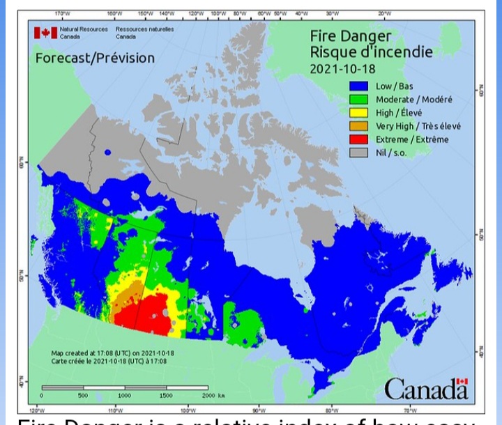
Fire Danger is a relative index of how easy it is to ignite vegetation, how difficult a fire may be to control, and how much damage a fire may do. Fires likely to be self-extinguishing and new ignitions unlikely are shown in blue. Any existing fires limited to smoldering in deep, drier layers. Credit: Natural Resources Canada.
“Zombie” fires
The British Columbia Wildfire Service is becoming increasingly concerned about the threat of “zombie fires” in the months to come. In the northern hemisphere, “zombie” forest fires, are ones that burn in the summer then smolder (often under the snowpack) over winter, only to re-ignite in spring. New research indicates these types of fires may be becoming more common as they are linked to warmer summers, which are happening more often as our climate changes.
The research, based on satellite imagery, tracked the occurrence and characteristics of these types of forest fires in the Northwest Territories and Alaska, USA between 2002 and 2018.
A true colour satellite image of smoke from Arctic wildfires was captured on July 23, 2019. The fires appear as yellow-red dots. Credit: National Oceanic and Atmospheric Administration.
Overwintering fires are more common in lowland areas with thick organic soils and dense tree cover. The fires burn with high intensity deep into the soil, which is then what enables them to survive winter.
Canada’s boreal zone stretches from Yukon and northern British Columbia to Newfoundland & Labrador. Credit: Natural Resources Canada.
Higher temperatures in boreal regions have already led to intensified drought and longer-lasting fire seasons. Longer fire seasons allow fires to spread faster and grow larger, thereby leading to a greater area burned. Summer heat and drought deeply dry organic surfaces and fuels—that burn very easily—and therefore create these deep burning and long-lasting fires.
Fire locations from 1980 to 2019 collected by the Canadian National Fire Database. Fires of all sizes are included in the database, but only those greater than 200 hectares in final size are shown in the map above—these represent a small percentage of all fires but account for most of the area burned (usually more than 97%). Credit: Natural Resources Canada.
Climate change and zombie fires
Scientists believe that increasing summer temperatures associated with climate warming may promote the survival of overwintering fires in the future. Likewise, the earlier onset of fire weather conditions in the spring, may lead to an overall larger percentage of these fires occurring.
For more on the fire weather conditions in Canada: Current fire weather index maps.


