**** Info via Environment Canada
**** Info via Environment Canada
ENDED
Well, it changed again
Severe thunderstorm watch in effect

Conditions are favourable for the development of severe thunderstorms that may be capable of producing strong wind gusts, large hail and heavy rain.
Potential rainfall rates: 25 mm per hour or higher in thunderstorms.
Potential wind gusts: locally 90 km/h or higher in thunderstorms.
Potential hail: possibly exceeding nickel sized hail.
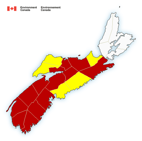
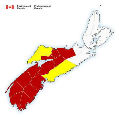
Locations: All of mainland Nova Scotia.
Time span: this afternoon until this evening.
Lightning kills and injures Canadians every year. Remember, when thunder roars, go indoors!
Severe thunderstorm watches are issued when atmospheric conditions are favourable for the development of thunderstorms that could produce one or more of the following: large hail, damaging winds, torrential rainfall.
Please continue to monitor alerts and forecasts issued by Environment Canada. To report severe weather, send an email to [email protected] or tweet reports using #NSStorm.
Severe thunderstorm warning in effect
At 2:54 p.m. ADT, Environment Canada meteorologists are tracking a severe thunderstorm capable of producing strong wind gusts, up to nickel size hail and heavy rain.
A cluster of thunderstorms in Hants County is giving hail of 25 mm or more.
Wind gusts: up to 90 km/h possible
Hail: greater than 20 mm observed
Rain: 25 mm/h possible.
This severe thunderstorm is located near Micmac (Hants), moving southeast at 65 km/h.
Hazard: 90 km/h wind gusts and nickel size hail.
Locations impacted include:
Halifax, Dartmouth, Stewiacke, Lakelands (Hants), Mount Uniacke, Bell Provincial Park, Hammonds Plains Road, Upper Sackville, Upper Rawdon, Middle Sackville, Beaver Bank, Glen Moir, Lower Sackville, Rockingham, Sackville Lakes Provincial Park, Bedford, Windsor Junction, Fall River West, Upper Nine Mile River and Barr Settlement.
Lightning kills and injures Canadians every year. Remember, when thunder roars, go indoors!
Severe thunderstorm warnings are issued when imminent or occurring thunderstorms are likely to produce or are producing one or more of the following: large hail, damaging winds, torrential rainfall.
Please continue to monitor alerts and forecasts issued by Environment Canada. To report severe weather, send an email to [email protected] or tweet reports using #NSStorm
.
Severe thunderstorm watch in effect
Conditions are favourable for the development of severe thunderstorms that may be capable of producing strong wind gusts and heavy rain.
Potential rainfall rates: 25 mm per hour or higher in thunderstorms.
Potential wind gusts: locally 90 km/h or higher in thunderstorms.
Locations: All of mainland Nova Scotia except the Antigonish and Guysborough counties.
Time span: this afternoon until this evening.
Remarks: A line of thunderstorms over the Bay of Fundy is moving east-southeast towards northern Nova Scotia and has the potential to produce heavy downpours and gusty winds. Thunderstorms are also expected to develop over the rest of Nova Scotia this afternoon.
Lightning kills and injures Canadians every year. Remember, when thunder roars, go indoors!
Severe thunderstorm watches are issued when atmospheric conditions are favourable for the development of thunderstorms that could produce one or more of the following: large hail, damaging winds, torrential rainfall.
Please continue to monitor alerts and forecasts issued by Environment Canada. To report severe weather, send an email to [email protected] or tweet reports using #NSStorm.