**** Via Environment Canada
Update via Environment Canada
Environment Canada has lifted all warnings for HRM in regards to Hurricane Teddy
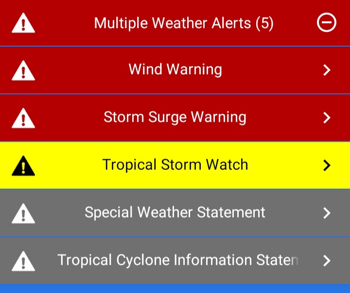
Multiple warning in effect

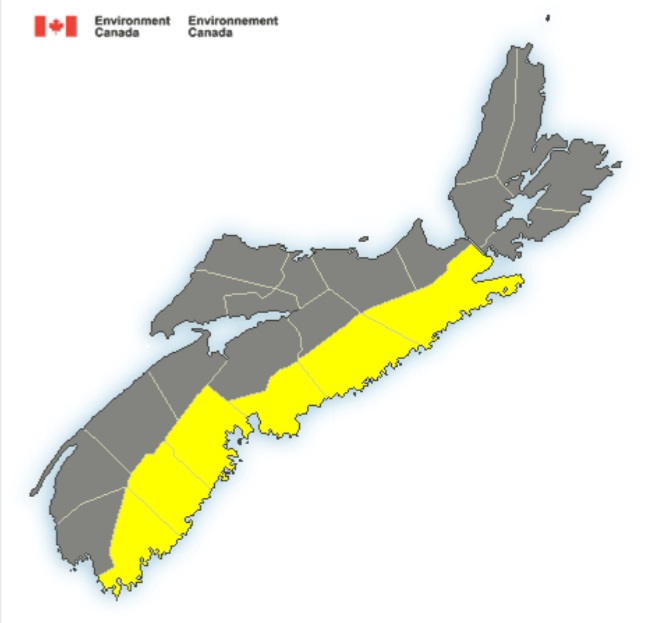
Tropical storm force winds of 60 gusting to 90 km/h over exposed areas from Tropical Storm Teddy can be expected over the above regions.
Tropical storm force winds ahead of Hurricane Teddy expected to begin affecting parts of Nova Scotia late on Tuesday, accompanied by rain at times heavy in the afternoon and evening.
Potential wind gusts: 65 to 100 km/h over exposed areas and along parts of the
coast.
Locations: Coastal regions of mainland Nova Scotia and Cape Breton
Time span: From noon Tuesday into Late Wednesday.
Remarks: Tropical storm force northeasterly winds will develop across much of Nova Scotia ahead of Hurricane Teddy on Tuesday. Winds are expected to gust to 80 to 100 km/h over exposed areas and along parts of the coast Tuesday afternoon and evening. Another period of strong winds is possible Wednesday morning over easternmost sections of Nova Scotia as Teddy makes its closest approach to the
province.
.
Rainfall warning in effect for:
- Halifax Metro and Halifax County West
Rain, at times heavy, is expected.
Total rainfall amount: 50 to 75 mm, possibly reaching 100 mm in areas of heaviest rain.
Locations: Lunenburg, Halifax, and Guysborough Counties
Time span: beginning late Tuesday morning and continuing into Wednesday.
Remarks: The initial rain bands ahead of Hurricane Teddy will reach the Atlantic coast of Nova Scotia late Tuesday morning. Rain will be heavy at times through the afternoon and then diminish somewhat in the evening.
A second burst of heavier rain is expected just ahead of Teddy as it approaches the coast overnight on Tuesday and into Wednesday morning.
Total amounts may exceed 50 mm by 6 a.m. Wednesday, with total rainfall possibly reaching 100 mm in areas of heaviest rain by Wednesday night. This warning is likely to be expanded with future updates.
Heavy downpours can cause flash floods and water pooling on roads. Localized flooding in low-lying areas is possible.
Rainfall warnings are issued when significant rainfall is expected.
.
These winds could break tree branches potentially resulting in downed utility lines. Stay away from the shore – the combination of surge and large waves could result in dangerous rip currents and the risk of being pulled out to sea.
A tropical storm warning means that tropical storm conditions (sustained winds near 65 km/h or more) are expected over parts of the region within 24 hours.
By nature, a tropical storm also implies the threat of local flooding from heavy rainfall – consult your local area forecast for possible rainfall warnings.
Please continue to monitor alerts issued by the Canadian Hurricane Centre and forecasts issued by Environment Canada. Reports of storm conditions and impacts can be emailed directly to [email protected] or by tweeting reports by province using #NSStorm, #NBStorm, #PEStorm, #NLwx, #QCStorm or #ONStorm.
10:25 AM ADT Monday 21 September 2020
Wind warning in effect
Strong winds that may cause damage are expected or occurring.
Maximum gusts: northeasterly 90 km/h along parts of the coast.
Locations: Along the Atlantic coast of mainland Nova Scotia.
Time span: Tuesday afternoon until late Tuesday evening.
Damage to buildings, such as to roof shingles and windows, may occur. High winds may toss loose objects or cause tree branches to break.
Wind warnings are issued when there is a significant risk of damaging winds.
.

Update: Storm surge warning:
High Storm Surge levels and very large waves are expected to impact the coast.
High waves combined with the surge may cause damage along the coast. Coastal erosion is likely in vulnerable areas. Coastal flooding is possible along the shoreline.
Storm surge warnings are issued when water levels pose a threat to coastal regions.
.
Strong winds that may cause damage are expected or occurring.
Maximum gusts: northeasterly 90 km/h along parts of the coast.
Locations: Along the Atlantic coast of mainland Nova Scotia.
Time span: Tuesday afternoon until late Tuesday evening.
Damage to buildings, such as to roof shingles and windows, may occur. High winds may toss loose objects or cause tree branches to break.
Wind warnings are issued when there is a significant risk of damaging winds.
.
A watch has been issued from Environment Canada. (ENDED)
Tropical storm force winds of possible 70 gusting to 100 km/h over exposed areas from Hurricane Teddy may occur over the above regions.
Hurricane Teddy will approach Atlantic Canada on Tuesday and will track through the region Tuesday night and Wednesday.
Potential wind gusts: 100 km/h or possibly higher over exposed areas along the Atlantic coast.
Locations: Atlantic coastal regions of Nova Scotia.
Time span: Tuesday afternoon into Tuesday evening.
Remarks: A band of very strong easterly or northeasterly winds, likely gusting to 100 km/h or higher over exposed areas, is expected to develop during the day Tuesday and be strongest Tuesday afternoon and evening. Another period of strong winds is also likely Wednesday morning as Teddy as pulls away and moves off to the east.
A tropical storm watch means that tropical storm conditions (sustained winds near 65 km/h or more) are possible over parts of the region within 36 hours.
By nature, a tropical storm also implies the threat of local flooding from heavy rainfall – consult your local area forecast for possible rainfall warnings.
Please continue to monitor alerts issued by the Canadian Hurricane Centre and forecasts issued by Environment Canada. Reports of storm conditions and impacts can be emailed directly to [email protected] or by tweeting reports by province using #NSStorm, #
More information: