**** Via Environment Canada
**** All ended

A new special weather statement is in effect via Environment Canada. Check out the link for more information:
http://weather.gc.ca/warnings/index_e.html?prov=ns
“Higher than normal water levels are expected today.
Locations: Atlantic coast of Nova Scotia.
Time span: during high tide this morning.
The combination of storm surge from a passing low pressure system and strong winds will create higher than normal water levels and rough and pounding surf this morning during high tide.
Please continue to monitor alerts and forecasts issued by Environment Canada. To report severe weather, send an email to [email protected] or tweet reports using #NSStorm.”
.
**** ENDED
A wind warning is in effect via Environment Canada. Check out the link for more information:
http://weather.gc.ca/warnings/index_e.html?prov=ns

Strong winds that may cause damage are expected or occurring.
Maximum gusts: easterly 70 to 80 km/h, except 90 along parts of the coast.
Locations: Atlantic coast of Nova Scotia and Cape Breton.
Time span: Will develop over western Nova Scotia this evening and spread eastward overnight.
Loose objects may be tossed by the wind and cause injury or damage.
Wind warnings are issued when there is a significant risk of damaging winds.
Please continue to monitor alerts and forecasts issued by Environment Canada. To report severe weather, send an email to [email protected] or tweet reports using #NSStorm.”
.
****ENDED
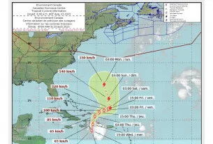
(Weather) Special weather statement in effect via Environment Canada.

“Maximum wind gusts: 70 km/h except 90 along the coast.
Water Levels: Large waves, pounding surf and elevated water levels are expected, likely exceeding high astronomical tide. Shore or beach erosion and damage to coastal infrastructure is possible in vulnerable areas along Digby and Yarmouth counties and along the South Shore.
Total rainfall: 10 to 20 mm. Locally higher amounts possible.
Total snowfall: Over northern Nova Scotia including Cape Breton, 5 cm except 10 or more over higher terrain.
Time span: Thursday night into Friday.
Remarks: Snow is expected to begin Thursday evening and then change to rain by Friday morning. The snow will persist until midday Friday over Cape Breton. Strong winds will also develop, with the highest gusts occurring over coastal areas. Conditions will improve late Friday.
Please continue to monitor alerts and forecasts issued by Environment Canada. To report severe weather, send an email to [email protected] or tweet reports using #NSStorm.”