**** Info via Environment Canada
Tropical Cyclone Information Statements
**** ENDED
Tropical cyclone information statement for:
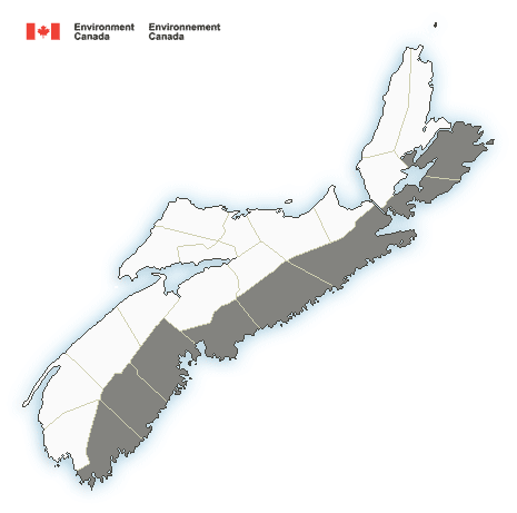
Nova Scotia:
- Guysborough County
- Halifax County – east of Porters Lake
- Halifax Metro and Halifax County West
- Lunenburg County
- Queens County
- Richmond County
- Shelburne County
- Sydney Metro and Cape Breton County
For Tropical Depression Claudette.
Update
For Tropical Storm Claudette.
1. Summary of basic information at 9:00 a.m. ADT.
Location: 36.1 North 76.4 West.
About 95 km south-southwest of Norfolk, Virginia.
Maximum sustained winds: 65 kilometres per hour.
Present movement: east-northeast at 41 kilometres per hour.
Minimum central pressure: 1005 mb.
2. Public weather impacts and warnings summary.
Periods of heavy rain are likely over parts of Nova Scotia and Newfoundland Tuesday and Tuesday night.
a. Wind.
Gusty winds are possible over parts of Nova Scotia and Newfoundland. However, these winds are not expected to approach warning criteria of 90 km/h.
b. Rainfall.
Periods of heavy rainfall are expected and may produce significant amounts of rain in a very short period of time. This may cause pooling of water and localized flooding in vulnerable areas.
c. Surge/Waves.
No significant waves or storm surge are expected with Claudette.
3. Marine weather impacts and warnings summary.
Winds will approach gale-force over the offshore waters of Nova Scotia and Newfoundland.
Forecaster(s): Hatt
Please continue to monitor alerts issued by the Canadian Hurricane Centre and forecasts issued by Environment Canada.
.
Tropical Depression Claudette may affect Atlantic Canada Tuesday and Tuesday night.
Tropical Depression Claudette is moving slowly northeastward over the southeastern US today and tonight. Despite being over land for a while and fairly high central pressure, it is expected to move back over the ocean intact and regain Tropical Storm intensity off the Carolinas. The system is expected to track south of Nova Scotia and any remaining winds will be well offshore. There is also a possibility the low could simply weaken to a basic trough of low pressure by Tuesday, at which point the CHC would end messages. Regardless, Nova Scotia and then Newfoundland may see some heavy downpours on Tuesday and Tuesday night while gale-force winds would likely occur over southern Canadian waters .