*** Info via Environment Canada
(Photos Sean Dewitt)
Hurricane Juan Storm Summary

At 12:10 a.m. ADT, Monday, September 29, 2003, Hurricane Juan made landfall in Nova Scotia between Shad Bay and Prospect. Juan arrived as a Category 2 storm. The storm ripped northward through the province, weakening quickly as tropical cyclones do over land. Arrive in Prince Edward Island as a marginal hurricane.

Environment Canada weather specialists are examining the data, ranging from radar to satellite to surface observations to aerial photographs of damage. As information becomes available and we learn more about the storm’s nature and impacts it will be posted here. We fully expect to be adding continually to this site in the coming weeks and months.

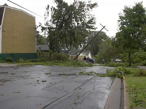
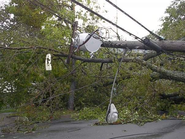
To date, Juan has claimed the lives of eight individuals: two when trees fell on their motor vehicle, two fishermen near Anticosti Island, three in a house fire speculated to have been started by candles used during the power outage, and one involved in relief work weeks after the storm. Hurricane Juan will be recorded as the most damaging storm in modern history for Halifax, Nova Scotia (as measured by the widespread tree blow-downs, power outages, and damaged homes). Hundreds of thousands of Maritimers in Nova Scotia and Prince Edward Island lost power when the storm passed Sunday night . Nova Scotia Power reported that the last of their affected customers had power restored by the morning of Sunday October 12: just short of 2 weeks. The last time that the city of Halifax was hit by the eastern eyewall of a hurricane (the worst winds in such a storm) was on August 22, 1893, when a Category 3 ( sustained winds of about 180 km/h) storm made landfall in St. Margaret’s Bay near 3.00 a.m. ADT. That storm, known then as “the second Great August Gale,” claimed 25 lives and sank the vessels “Dorcas” and “Etta Stewart.”
Quick Facts
To satisfy an immediate need for information, here are some quick facts about Juan and it’s impacts.
- Juan began as Tropical Depression about 470 km southeast of Bermuda at noon ADT, Thursday, September 25. Six hours later it was upgraded to Tropical Storm Juan.
- 24 hours after being declared to be a tropical depression, Juan became a hurricane 255 km east of Bermuda.
- Juan made landfall on the coast of Nova Scotia at 12:10 a.m. on the morning of Monday, September 29. It came ashore between Shad Bay and Prospect.
- Detailed investigation indicates that the storm’s strength was a Category 2 hurricane, 158 km/h, sustained with gusts to over 185 km/h.
- Estimated diameter of the hurricane eye at landfall is 35 km (from Hubbards to the west end of Halifax).
- Estimated central pressure of Juan at landfall was 973 mb .
- The storm tracked almost due north, crossing the Northumberland Strait around 3 a.m. ADT (near or over the eastern portion of the Confederation Bridge) and crossed Prince Edward Island (landfall close to or east of Borden) in less than an hour.
- The highest sustained winds (2-minute mean) recorded by a land station were 151 km/h at McNab’s Island, in Halifax Harbour, with gusts to 176 km/h at 12:24 a.m. ADT (communication failure at the McNab’s site prevented weather office from seeing this data until later).
- The maximum wind core (eastern eyewall) went right over Halifax Harbour.
- Juan dropped below hurricane strength (determined by sustained winds, not gusts) as it crossed Prince Edward Island Charlottetown airport reported a sustained wind of 95 km/h and gusts to 139 km/h at 3:17 a.m. ADT.
- Rainfall amounts in the vicinity of 25-40 millimetres (from Juan only) were reported from around the Halifax Regional Municipality.
- Storm surge values ranged from around 1 metre (as far west as Mahone Bay) to 1.5 metres (measured by a tide gauge in Halifax Harbour) to more than 1.5 metres in Cow Bay (based on damage). Halifax harbour recorded an all time record water level of 290 cm which resulted in extensive flooding of the Halifax waterfront properties.
- Significant wave heights of well over 10 metres were expected (although not measured) along the Eastern Shore of Nova Scotia, as far east as Ecum Secum. The largest significant waves recorded at the coast were 9 metres at Halifax Harbour with maximum waves of 19.9 metres.
- Aerial surveys indicate that the area of greatest impact (to property and trees) extended along the Atlantic Coast of Nova Scotia from Shad Bay to Clam Harbour.