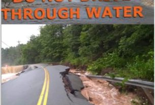
**** Info via Environment Canada
Rainfall warning is in effect, special weather statement is in effect

Rainfall warning
Rain, heavy at times is expected. The ground, already near saturation, has little ability to absorb further rainfall.
Locations: most of mainland Nova Scotia.
Total rainfall: 30 to 50 mm, with locally higher amounts possible.
Time span: beginning this evening and ending Thursday evening.
Remarks: Showers or rain will end later this morning before heavy rain redevelops tonight. Rain will transition through freezing rain, ice pellets, and snow Thursday evening before precipitation tapers off Thursday night.
Localized flooding in low-lying areas is possible.
Rainfall warnings are issued when significant rainfall is expected.
Special weather statement
Mild and wet conditions to turn into freezing rain, ice pellets, and snow.
Locations: Nova Scotia.
Maximum wind gusts: northeasterly 70 km/h.
Time span: overnight tonight until Thursday night.
Remarks: Precipitation will begin again as rain tonight and then change to freezing rain and ice pellets Thursday afternoon and evening. There is still some uncertainty in regards to the duration and extent of the freezing rain, but eastern and northern Nova Scotia are at the highest risk of an extended period of freezing rain.
Similar storms in the past have caused:
– hazardous driving conditions,
– traffic delays,
– scattered utility outages.
Please continue to monitor alerts and forecasts issued by Environment Canada. To report severe weather, send an email to [email protected] or tweet reports using #NSStorm.
Source
https://weather.gc.ca/?province=ns&zoom=6¢er=45.27007192,-63.21181060


