**** Info via Environment Canada
Updated warnings and watches for the HRM
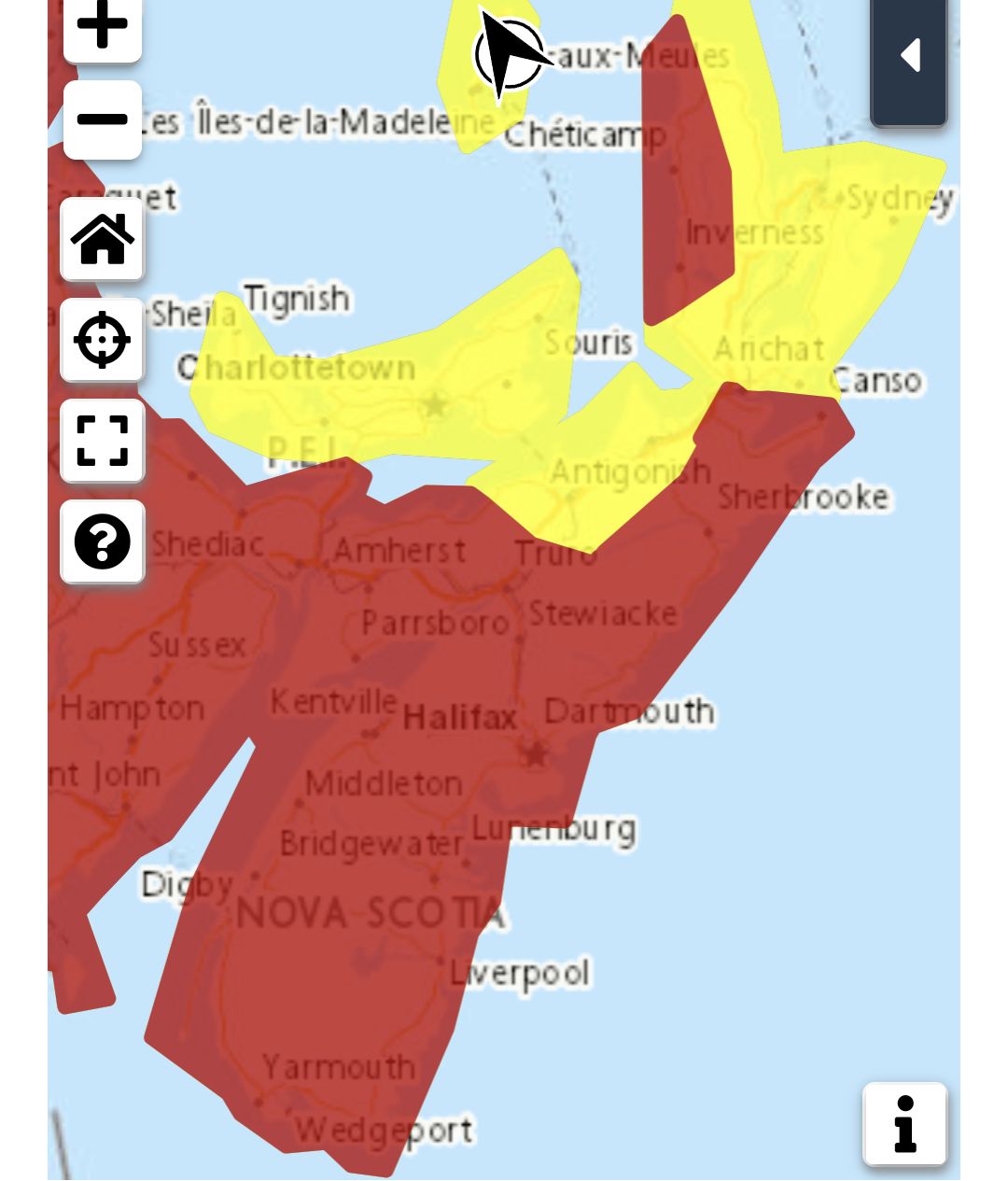
Storm surge warning
People near the coast should monitor for worsening conditions and be prepared to move to a safer location at a moment’s notice.
Impacts from storm surge are expected, including coastal flooding, beach erosion, infrastructure damage, spread of coastal debris, and localized coastal road washouts.
Locations: Atlantic coast of Mainland Nova Scotia, especially south-facing coastlines. Yarmouth County was added this morning.
Maximum Water Levels: exceeding high astronomical tide, with water
inundating sections of the coast exposed to waves from the south.
Maximum wave heights: 8 to 12 metres, breaking 4 to 6 metres for coastlines exposed to waves from the south.
Time span: Saturday morning until Saturday night. Worst near high tides.
First high tide: 6 A.M. to 10 A.M. Saturday.
Second high tide: 7 P.M. Saturday to 11 P.M. Saturday.
Remarks: Be sure to follow any instructions issued by local authorities.
Storm surge warnings are issued when water levels pose a threat to coastal regions.
.
Wind warning
Strong winds that may cause damage are expected or occurring.
Maximum gusts: 90 to 110 km/h.
Locations: most of mainland Nova Scotia.
Time span: ending tonight from west to east.
Damage to buildings, such as to roof shingles and windows, may occur. High winds may result in power outages and fallen tree branches.
Wind warnings are issued when there is a significant risk of damaging winds.
.
Tropical Storm warning
Tropical storm force winds of 70 gusting to 100 km/h over exposed areas from Hurricane Lee can be expected over the above regions.
Wind gusts of 90 to 110 km/h are expected, potentially higher in the areas also under a Hurricane Watch (i.e. most of the southern half of mainland Nova Scotia). These conditions are expected to begin Saturday morning and persist into the evening.
These winds will likely topple some trees (leading to downed utility lines), damage signs and cause some property damage to roofing materials, cladding, fences and exterior fixtures. This could result in some damage to docks and breakwaters. Shoreline erosion and wave overwash is expected where winds blow onshore.
Secure loose objects on your property and anticipate power interruptions.
By nature, a tropical storm also implies the threat of local flooding from heavy rainfall – consult your local area forecast for possible rainfall warnings.
.
Hurricane watch
There is a possibility that Hurricane Lee could bring near-hurricane conditions.
These conditions could occur throughout the day and evening Saturday, with winds potentially gusting as high as 120 km/h. Heavy surf and storm surge is expected from the Yarmouth County shoreline and all along the Atlantic Coast of Nova Scotia to the Canso area. A surge warning is in effect.
A Tropical Storm Warning is in effect for the Hurricane Watch zone. Winds of 70 gusting to 100 km/h are expected with a risk of damaging hurricane force gusts of 120. This could result in the toppling of some trees and possibly minor property damage. Damage to some infrastructure along the coastline is to be expected.
A hurricane watch means that hurricane conditions are possible over parts of the region within 36 hours. Hurricane conditions include (A) sustained winds near 120 km/h or more, and/or (B) significantly elevated water levels and dangerous surf along the coast.
By nature, a hurricane also implies the threat of local flooding from heavy rainfall – consult your local area forecast for possible rainfall warnings.
.
Tropical Cyclone statement
The next full information statement will be issued by 09:00 am ADT, with the next intermediate statement at 12:00 pm ADT.
Lee now a powerful post-tropical cyclone and is now located over offshore Canadian waters. Lee will continue to batter much of the Maritimes today with heavy rain, strong winds, and high waves along the Atlantic coast.
1. Summary of basic information at 06:00 am ADT.
Location: Near 41.8 North 66.0 West.
About 365 kilometres south-southwest of Halifax
Maximum sustained winds: 130 kilometres per hour.
Present movement: North at 41 kilometres per hour.
Minimum central pressure: 965 millibars.
2. Summary of latest information.
Lee was officially declared post-tropical early this morning after the latest NOAA reconnaissance flight into the storm, however it will remain a very large and dangerous post-tropical cyclone as it continues to move toward the Maritimes today.
Bands of heavy rain moved into Nova Scotia Friday evening and are currently are affecting all but northwestern New Brunswick early this morning. As of 6:00 am 30 to 60 mm of rain has already fallen over southwestern Nova Scotia.
Winds will continue to increase across the region today. Gusts to 90 km/h have already been reported along the Atlantic coast of Nova Scotia from Halifax to Digby County, peaking at 108 km/h over Baccaro Point, Shelburne County. Nova Scotia Power is reporting over 22,000 customers are without power as of around 6:00 am.
.
Please continue to monitor alerts and forecasts issued by Environment Canada. To report severe weather, send an email to [email protected] or tweet reports using #NSStorm.
Source
https://weather.gc.ca/?province=ns&zoom=6¢er=45.42108923,-63.25362496