**** Info via Environment Canada
Updated – New warnings
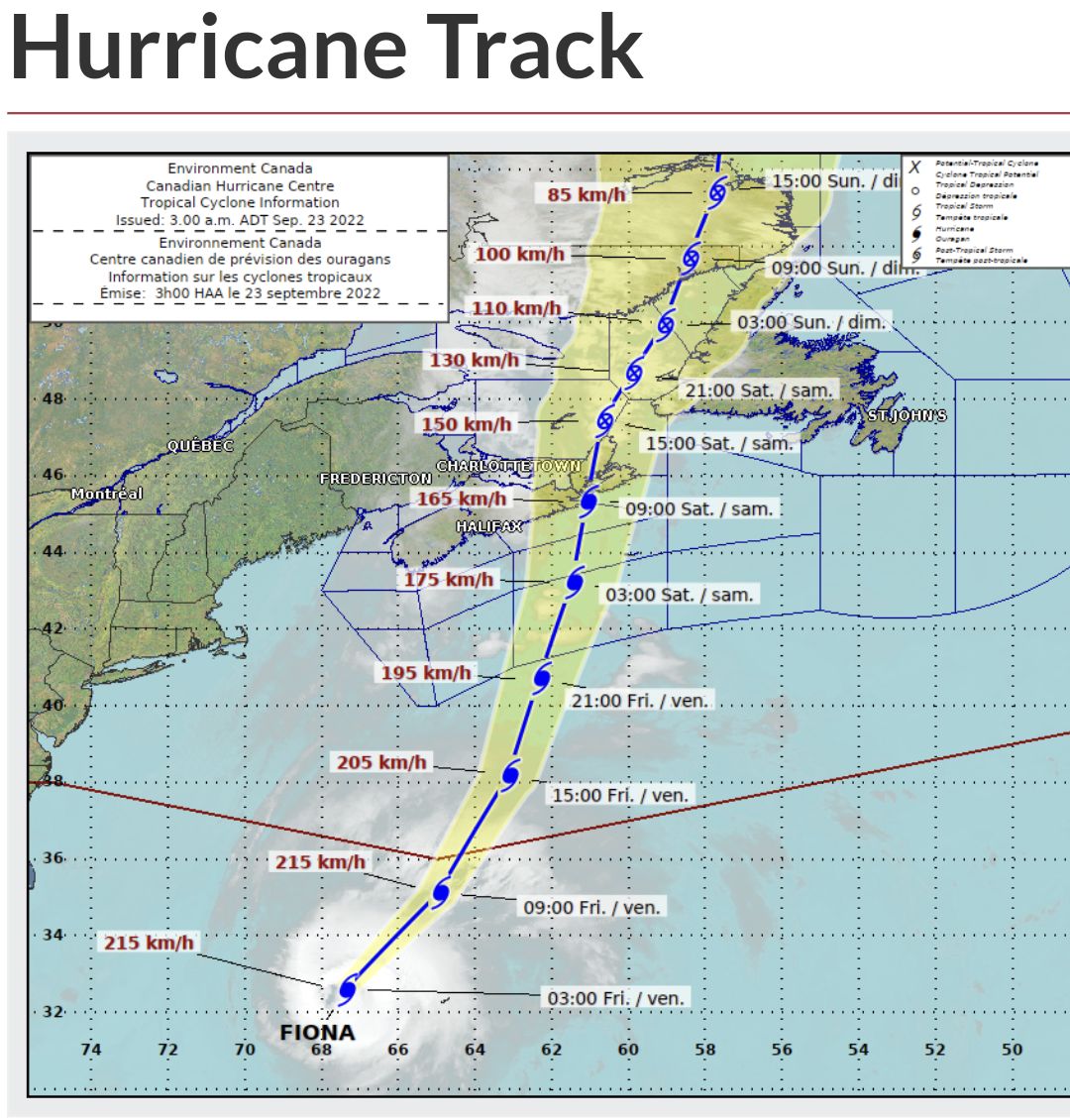
Hurricane warning in effect

Strong tropical storm force winds of 80 gusting to 120 km/h over exposed areas with surge of 1.0 to 1.3 m and waves from 7 to 10 m from Hurricane Fiona are expected.
This warning represents the region just outside the severe core of Hurricane / Severe Post-Tropical Fiona. Winds may gust to hurricane-force inland and a bit higher where winds blow onshore. Winds will be cold and from the northwest on the west side of the track between mainland Nova Scotia and Cape Breton and be from the south over western Newfoundland east of the track, and easterly along southern Newfoundland.
Local wind warnings will be issued with additional details and local effects.
This could result in moderate damage to docks and breakwaters. Significant shoreline erosion and wave overwash is expected where winds blow onshore. Stay away from the shore – the combination of surge and large waves could result in dangerous rip currents and the risk of being pulled out to sea.
A hurricane warning means that hurricane conditions are expected over parts of the region within 24 hours. Hurricane conditions include (A) sustained winds near 120 km/h or more, and/or (B) significantly elevated water levels and dangerous surf along the coast.
By nature, a hurricane also implies the threat of local flooding from heavy rainfall – consult your local area forecast for possible rainfall warnings.
Wind warning in effect
Strong winds with severe and damaging gusts are expected or occurring.
Maximum winds: northwesterly 50 to 80 km/h with gusts to 100 to 120 km/h.
Locations: central Nova Scotia.
Time span: this evening until noon Saturday.
Similar storms in the past have resulted in prolonged utility outages, hazardous driving conditions and toppling of high sided vehicles.
High winds may cause downed trees or toss loose objects. Utility outages may occur.
Wind warnings are issued when there is a significant risk of damaging winds.
Rainfall warning in effect
Extremely heavy rain is expected.
Total rainfall: 100 to 150 mm, local amounts possibly reaching 200 mm.
Locations: central, northern and eastern mainland Nova Scotia.
Time span: today through to Saturday afternoon.
Remarks: A trough of low pressure is bringing rain to the region today. This trough will merge with approaching Hurricane Fiona later today and will bring intense and torrential rainfall to the region. Rainfall rates in excess of 25 mm per hour are likely beginning tonight and will continue into Saturday.
Past storms with these rainfall rates and total accumulations have caused hazardous driving conditions, flooded basements, elevated river levels, road shoulder erosion and washouts, road closures, and localized flooding, especially in poor drainage areas.
Heavy downpours are likely to cause flash floods and water pooling on roads. Rapidly rising rivers and creeks can sweep away bridges, culverts, buildings, and people. Don’t approach washouts near rivers, creeks and culverts.
Rainfall warnings are issued when significant rainfall is expected.
Wind warning in effect
Strong winds with severe and damaging gusts are expected or occurring.
Maximum winds: northwesterly 50 to 80 km/h with gusts to 100 to 120 km/h.
Locations: central Nova Scotia.
Time span: this evening until noon Saturday.
Similar storms in the past have resulted in prolonged utility outages, hazardous driving conditions and toppling of high sided vehicles.
High winds may cause downed trees or toss loose objects. Utility outages may occur.
Wind warnings are issued when there is a significant risk of damaging winds.
Please continue to monitor alerts and forecasts issued by Environment Canada. To report severe weather, send an email to [email protected] or tweet reports using #NSStorm.