**** Info via Environment Canada
Updated Tropical Cyclone Information Statement
The next information statement will be issued by 3:00 p.m. ADT.
Fiona expected to impact Atlantic Canada and eastern Quebec with heavy rainfall and powerful hurricane force winds beginning early Saturday.
1. Summary of basic information at 09:00 a.m. ADT.
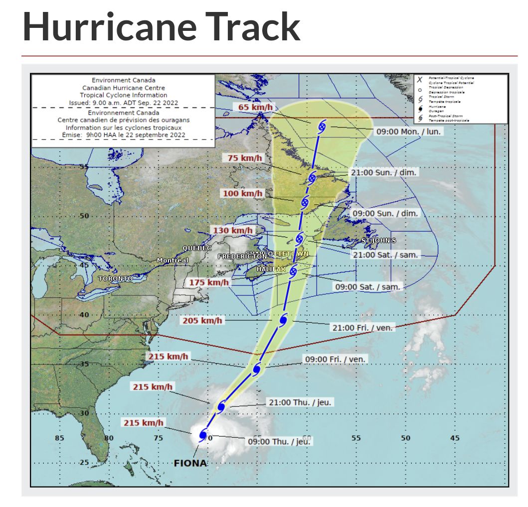
Location: 28.0 North 70.6 West.
About 2006 kilometres south-southwest of Sable Island.
Maximum sustained winds: 213 kilometres per hour.
Present movement: north-northeast at 24 kilometres per hour.
Minimum central pressure: 934 millibars.
2. Public weather impacts and warnings summary.
This storm is shaping up to be a severe event for Atlantic Canada and eastern Quebec. Numerous weather models are quite consistent in their prediction of what we call a deep hybrid low pressure system, possessing both tropical and intense winter storm properties, with very heavy rainfall and severe winds.
The latest forecast guidance brings Hurricane Fiona north towards Nova Scotia waters Friday night, passing through eastern Nova Scotia and Cape Breton Saturday, and then reaching the Lower Quebec North Shore and Southeastern Labrador early Sunday. Severe winds and rainfall will have major impacts for eastern Prince Edward Island, eastern Nova Scotia, western Newfoundland, eastern Quebec, and southeastern Labrador. There will also be large waves, especially for the Atlantic coasts of Nova Scotia, Newfoundland, and eastern portions of the Gulf of St. Lawrence. Finally, there is a high likelihood of storm surge for parts of Nova Scotia, the Gulf of St. Lawrence and western Newfoundland.
a. Wind.
Most regions will experience some hurricane force winds. These severe winds will begin impacting the region late Friday and will continue on Saturday. Similar cyclones of this nature have produced structural damage to buildings. Construction sites may be particularly vulnerable. Wind impacts will likely be enhanced by foliage on the trees, potentially causing prolonged utility outages
b. Rainfall.
Rainfall will be significant, especially north and west of Fiona’s track, where heavy rain could lead to flooding. The highest rainfall amounts are likely for eastern Nova Scotia, southwestern Newfoundland and the Gulf of St. Lawrence region. Forecast guidance is suggesting widespread amounts of 100 to 200 mm, but closer to the path of Fiona, more than 200 mm is likely. Some districts have received large quantities of rain recently, and excessive runoff may exacerbate the flooding potential. Road washouts and erosion are also possible.
c. Surge/Waves.
There will also be some rough and pounding surf, especially for parts of Nova Scotia and Newfoundland. Large waves will reach the eastern shore of Nova Scotia from the south Friday night and build to more than 10 metres. These waves will likely reach southern Newfoundland by Saturday morning. Some of the waves over eastern portions of the Gulf of St. Lawrence could be higher than 12 metres, and the western Gulf will see waves from the north up to 8 metres in places, which will probably cause significant erosion for north facing beaches of Prince Edward Island. Iles-de-la-Madeleine will also see some coastal erosion from waves.
Coastal flooding will also be a threat for parts of Nova Scotia, Prince Edward Island including the Northumberland Strait, the Gulf of St. Lawrence region including Iles-de-la-Madeleine and eastern New Brunswick, and southwest Newfoundland. The highest risk for coastal flooding will be a combination of storm surge with large wave moving onshore. There may also be some coastal flooding for the St. Lawrence Estuary and the Quebec Lower North Shore. For most areas the highest water levels will be near high tide some time on Saturday morning.
3. Marine weather impacts and warnings summary.
Hurricane force southeasterlies should spread into Scotian Slope waters Friday evening, and these winds will persist near and south of the track. Gale to storm force winds will impact all remaining marine waters. As the storm moves into the Maritimes, storm to hurricane force northwesterlies will likely develop west of the storm track. Waves in excess of 12 metres should form east of the hurricane track,

Forecaster(s): Mercer/Roch/March
Please continue to monitor alerts issued by the Canadian Hurricane Centre and forecasts issued by Environment Canada.
Hurricane tracker