**** Info via Environment Canada
**** ENDED
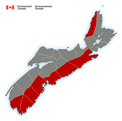
Update: Rain and wind warnings have been issued via Environment Canada
**** ENDED. Rainfall warning in effect
Rain, at times heavy, is expected.
Total rainfall: 40 to 70 mm.
Locations: The Atlantic coast of mainland Nova Scotia.
Time span: Tuesday morning or afternoon and persisting into Wednesday.
Remarks: Snow will change to rain, at times heavy Tuesday morning in the southwest and Tuesday afternoon in the east. The rain will taper to showers Wednesday morning or afternoon.
Heavy downpours can cause flash floods and water pooling on roads. Localized flooding in low-lying areas is possible.
Rainfall warnings are issued when significant rainfall is expected.
.
**** ENDED Wind warning in effect
Strong winds that may cause damage are expected or occurring.
Maximum gusts: easterly 80 km/h, except 100 km/h along parts of the coast.
Locations: Atlantic coast of mainland Nova Scotia.
Time span: Tuesday morning in the southwest and Tuesday afternoon in the east.
Remarks: High water levels and large waves are expected especially along the Atlantic Coast near high tide Tuesday night.
High winds may toss loose objects or cause tree branches to break.
Wind warnings are issued when there is a significant risk of damaging winds.
Please continue to monitor alerts and forecasts issued by Environment Canada. To report severe weather, send an email to [email protected] or tweet reports using #NSStorm.
More information: http://weather.gc.ca/warnings/index_e.html?prov=ns
.
**** ENDED
A special weather statement in effect via Environment Canada
Significant snow, rain and wind is expected.
Total snowfall: 5 to 20 cm.
Total rainfall: 30 to 60 mm.
Maximum wind gusts: 70 km/h except 100 along parts of the coast.
Locations: Nova Scotia.
Time span: Tuesday morning until Wednesday.
Remarks: Snow is expected to begin early Tuesday morning over southwestern Nova Scotia and then spread northeastward reaching Cape Breton by Tuesday afternoon. The snow will change to rain throughout the province Tuesday night. A period of ice pellets or freezing rain is likely during the changeover. Very strong easterly winds will accompany the precipitation. In addition, high water levels and large waves are expected especially along the Atlantic Coast near high tide Tuesday night. Conditions will improve during the day Wednesday.
Please continue to monitor alerts and forecasts issued by Environment Canada. To report severe weather, send an email to [email protected] or tweet reports using #NSStorm.
More information: http://weather.gc.ca/warnings/index_e.html?prov=ns