**** Info via Canadian, ca
Halifax Harbour boardwalk BioKit circuit
Introduction
Welcome to your Halifax Harbour Boardwalk BioKit Circuit. Use the activities in this circuit, with the HRM Urban BioKit, to explore the natural treasures and unique places in this park – utilizing your keen powers of observation.
Location: Along the Halifax Harbour boardwalk between Purdys Wharf and Salter Street.

History
The harbour has been the centre of cultural, economic and military activity in Halifax since its founding in 1749. Before European settlement, the harbourfront and much of downtown Halifax were marshland. Early European pioneers began a process of filling in the waterfront and building docks. Building on the waterfront has continued to the present with the construction of piers, bridges, housing and the boardwalk. Two small raw sewage treatment plants have been built in order to improve water quality.
Despite historic concerns about water and air pollution, many creatures can be found within this ecosystem. A variety of plants and animals use the harbour as habitat, though experts believe far fewer are present now than in the past. Several species of marine animals can still be observed in Halifax Harbour, such as harbour seals, dabbling ducks, Osprey, and occasionally porpoises.
Let’s explore it!
Harbour Bird Habitat
At the end of Purdys Wharf
GPS: N 44° 39.158′ W 63° 34.406′
Urban environments can often be hazardous for wildlife, but occasionally, either through good design or by accident, human-made wildlife habitat is created. The Halifax waterfront is a good location to see animals co-existing with humans in an urban environment.
Standing at this point, especially during the winter months, you can spot large groups of birds in the area between this dock and the naval base. Why do you think this is?
How many species of birds did you count?
Historic Properties
GPS: N 44° 39.042′ W 63° 34.373′
This four-acre National Historic Site features a group of buildings built by Halifax merchants in the early 1800s until 1905. These buildings have welcomed privateers, tourists and merchants from around the world. They represent the most significant pre-Confederation complex of maritime commercial buildings in Canada.
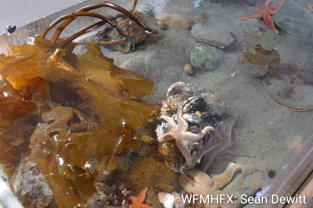
Explore: Go to point #2 on your map and scan the rocky waters below. This is a great opportunity to get a close look at unusual sea creatures and how they adapt to their urban surroundings. Evolution has created some sea creatures with strange appearances. Note the sea creature adaptations you observe.
Sea Creature Adaptations
- Pointy spines
- Hard shells
- Extreme flatness
- Bright colours
- Fast swimmer
- Many legs
- Claws
- No eyes
- An odd number of arms
Going Up or Down!
Near the Ferry Terminal
GPS: N 44° 39.014′ W 63° 34.309′
Tidal cycles play an important role in aquatic ecosystems.
Experiment: One way to tell whether the tide is going up or down is to observe a wooden dock pillar and see if mussels and barnacles attached to these posts are exposed to the air. If they are, the tide is below high tide. If they are entirely covered by water, the tide is high.
Do you see mussels and other sea life above water level? If so, estimate how many centimetres the water would have to rise to cover that sea life. Make another such estimate at the end of your harbour adventure and compare it with the above estimate to see if the tide is going up or down.
Dockyard Clock
GPS: N 44° 38.966′ W 63° 34.290′
Here you can see North America’s oldest operating naval clock, which was built in London, England, in 1767. It marks the landing site of Halifax’s first European settlers. Notice the golden weather vane atop the clock; it moves gently in the breeze that blows across the harbour. Observe this instrument or a nearby flag to determine from which direction the wind is blowing.
Halifax Harbour has been negatively affected by many forms of human-generated pollution. Although many creatures have adapted to the presence of humans in their habitat, many have not and can no longer be found living here.
Observe: Which of the following types of pollution you observe from where you’re standing.
- Oil or gas (from boats, cars, parking lots)
- Discarded food (from people, restaurants)
- Garbage (many types, such as tires, scrap metal, plastics)
- Sewage or drain debris
- Car and boat exhaust
- Smoke (from power plants, industry, buildings)
Marine life, such as sea turtles, can be harmed by litter and garbage discarded by humans.
The Underworld of Docks
GPS: N 44° 38.928′ W 63° 34.257
This is a great location to observe how marine biodiversity exists in urban environments that are heavily used and that, often, are polluted. Look into the shallow tidal area between the bridge and shore: from this elevated position, you can observe a variety of sea life.
Try your hand at drawing a few of the creatures you see in the waters.
Aquatic Shelters
Near Salter Street
GPS: N 44° 38.735′ W 63° 34.099′
Think about your adventure so far and how wildlife has formed a relationship with humans and their urban environment. The series of boardwalks and docks along the Halifax waterfront provides food and habitat for a number of animal species.
Many animals visible in the harbour scavenge our solid waste and live in the nooks and crannies of the wharf. Below is a list of creatures commonly seen along the Halifax waterfront. They are all adapted in some way to living with humans. Think about where each animal might live in the harbour, and match it up with its appropriate habitat.
Animal:
- Gulls: These seabirds are able to survive almost anywhere. They eat fish and scavenge discarded food.
- Harbour seals: These aquatic mammals eat fish and will often follow fishing vessels in search of food. They can also dive great distances under water.
- Norway rats: This invasive species was likely brought to Nova Scotia on board European ships. The Norway rat is a good swimmer, and can swim up to 24 metres under water at a time.
- Mink: This aquatic mammal is a relative of the otter. It hunts for fish and is commonly seen swimming in the harbour.
- Pigeons: This is a scavenger bird that is very common in urban areas throughout the world. Pigeons survive off of human waste, and are considered an invasive species.
Habitat:
- Under the dock: The water underneath the docks provides an aquatic habitat that is sheltered from sun, rain and wind.
- Open harbour: This deeper part of the harbour is not protected by human-made structures and is relatively teeming with boats, but is a good place to find fishes.
- Harbour rocks: These jagged stacks of rocks are full of holes and small tunnels. They provide the foundation for harbour wharfs and shelter for small mammals.
- Sewers and pipelines: Numerous pipes and sewers of many different shapes and sizes border the harbour.
- Wooden dock: The harbour boardwalk is popular with tourists and locals, both of whom provide good sources of leftover food for animals.