**** Info via Environment Canada
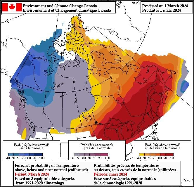
March temperature outlook via Environment Canada
Spring is already knocking on our door, as March 1st officially marks the start of meteorological spring. Will your region be chilling below average or sizzling above? Let’s have a look at the average temperature map for the month of March:
The forecasts are categorized as follows:
- blue is the likelihood that temperatures will be below normal.
- grey to purple is the likelihood that temperatures will be near normal.
- yellow to red is the likelihood that temperatures will be above normal.
- white is uncertainty about the temperature trend this month.

February overview
February temperatures were above-normal east of the Rockies, with central areas of the country, including parts of the British Columbia interior, eastern Saskatchewan, southern Manitoba, northern Ontario, and northwestern Quebec, finishing the month at least seven degrees above their monthly normal. The month started off with mild temperatures for much of the country, centring around Ontario and Quebec and subsiding mid-month. Towards the end of the month, while the east was mild again, a cold wave developed across the west, weakening as it moved eastward.
Precipitation anomalies were mixed, with parts of southern British Columbia interior, the Prairies, and northern Ontario receiving above-normal amounts while the Pacific Coast to northwestern Prairies, parts of Yukon and Northwest Territories, the Great Lakes through the Maritimes and parts of Newfoundland receiving below-normal amounts. While a storm brought snow to Nunavut on the last day of February, it was parts of Nova Scotia that captured national attention early in the month with an eye-popping snowfall amount, with 150 cm falling in Sydney, Nova Scotia.
.


