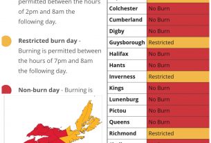
**** Info via Environment Canada
Updated
Special weather statement
Strong winds and rain are expected this weekend.
Maximum wind gusts: 70 to 80 km/h, potentially higher over exposed areas.
Total rainfall: 25 to 40 millimetres, but 50 or more possible in areas of heaviest rain.
Time span: beginning Saturday afternoon over western areas, later in the evening in the east. Conditions improving from west to east Sunday morning through Sunday afternoon.
Remarks: A trough of low pressure is expected to interact with approaching Tropical Storm Philippe and will combine to give heavy rain and strong winds to the region this weekend. Rainfall and wind warnings will likely be issued later today.
Please continue to monitor alerts and forecasts issued by Environment Canada. To report severe weather, send an email to [email protected] or tweet reports using #NSStorm.
.
Tropical cyclone statement
The next information statement will be issued by 9:00 a.m. ADT.
Strong southeasterly winds and periods of heavy rain associated with Tropical Storm Philippe and a strong trough of low pressure, will affect the region Saturday night and early Sunday morning.
1. Summary of basic information at 3:00 a.m. ADT.
Location: 28.8 North 66.0 West.
About 415 kiliometres south-southwest of Bermuda.
Maximum sustained winds: 85 kilometres per hour.
Present movement: north at 26 kilometres per hour.
Minimum central pressure: 1005 millibars.
2. Public weather impacts and warnings summary.
Increasing southeasterly winds and periods of rain, heavy at times, are expected to begin over southwestern Nova Scotia late Saturday afternoon or early Saturday evening. These conditions will spread eastward to the Halifax area later in the evening. Conditions will improve Sunday morning as the area of strong winds and periods of heavy rain move out of the area.
After collaboration between the Canadian Hurricane Centre, the National Hurricane Center in Miami and Weather Forecast Offices in Maine, it was decided that tropical watches and warnings would not be issued for Philippe and that the messaging would be handled by the local weather forecast office non-tropical alerting and forecast programs.
a. Wind.
Strong southeasterly winds gusting 70 to 80 kilometres per hour are expected with higher gusts over exposed areas possible. The strongest winds are expected to reach southwesternmost areas of the South Shore of Nova Scotia including Yarmouth and Shelburne by mid-evening Saturday. These winds should reach the Halifax area and the Annapolis Valley by midnight Saturday.
The winds are expected to diminish and shift to the southwest early Sunday morning over southwesternmost areas, including Yarmouth and Shelburne. This diminishing trend will reach the Annapolis Valley and Halifax area later Sunday morning.
b. Rainfall.
Many areas are expected to receive 30 millimetres of rainfall or more. There are indications that some areas of heaviest rain may receive 50 millimetres or more. In addition, there are indications that the heaviest rain may fall overnight Saturday night or early Sunday morning, especially just prior to conditions improving.
c. Surge/Waves.
Significant wave heights over marine areas south of Nova Scotia are expected to be in excess of 5 metres with 6 to 8 metres likely over much of the affected regions. The largest waves are expected Saturday night, subsiding during the day Sunday.
Large waves and storm surge with elevated water levels are expected along the South Shore of Nova Scotia and as far east as Halifax. These waves and storm surge will have some impact overnight Saturday night if the strongest winds and largest waves impacting coast occur near high tide. High tide near Halifax overnight Saturday night is at 4:13 am. High tide near Shelburne is at 4:50 am. Some coastal flooding is possible. However, there is uncertainty as to whether or not the largest waves and storm surge will occur near high tide.
Waves and high water levels are not expected to cause significant impact in the Bay of Fundy region due to the fact that the strong wind will be from an easterly direction limiting the fetch and the tidal cycle is in a low run of high tides.
3. Marine weather impacts and warnings summary.
Storm warnings have been issued for Lurcher, Browns Bank, Georges Bank, Southwestern Shore, Lahave Bank, West Scotian Slope and East Scotian Slope – southwestern half. Gale warnings are in effect for Halifax Harbour and approaches, Fundy, Grand Manan, Eastern Shore – western half and Sable – western half.
Source
https://weather.gc.ca/?province=ns&zoom=6¢er=45.60263890,-63.26467169