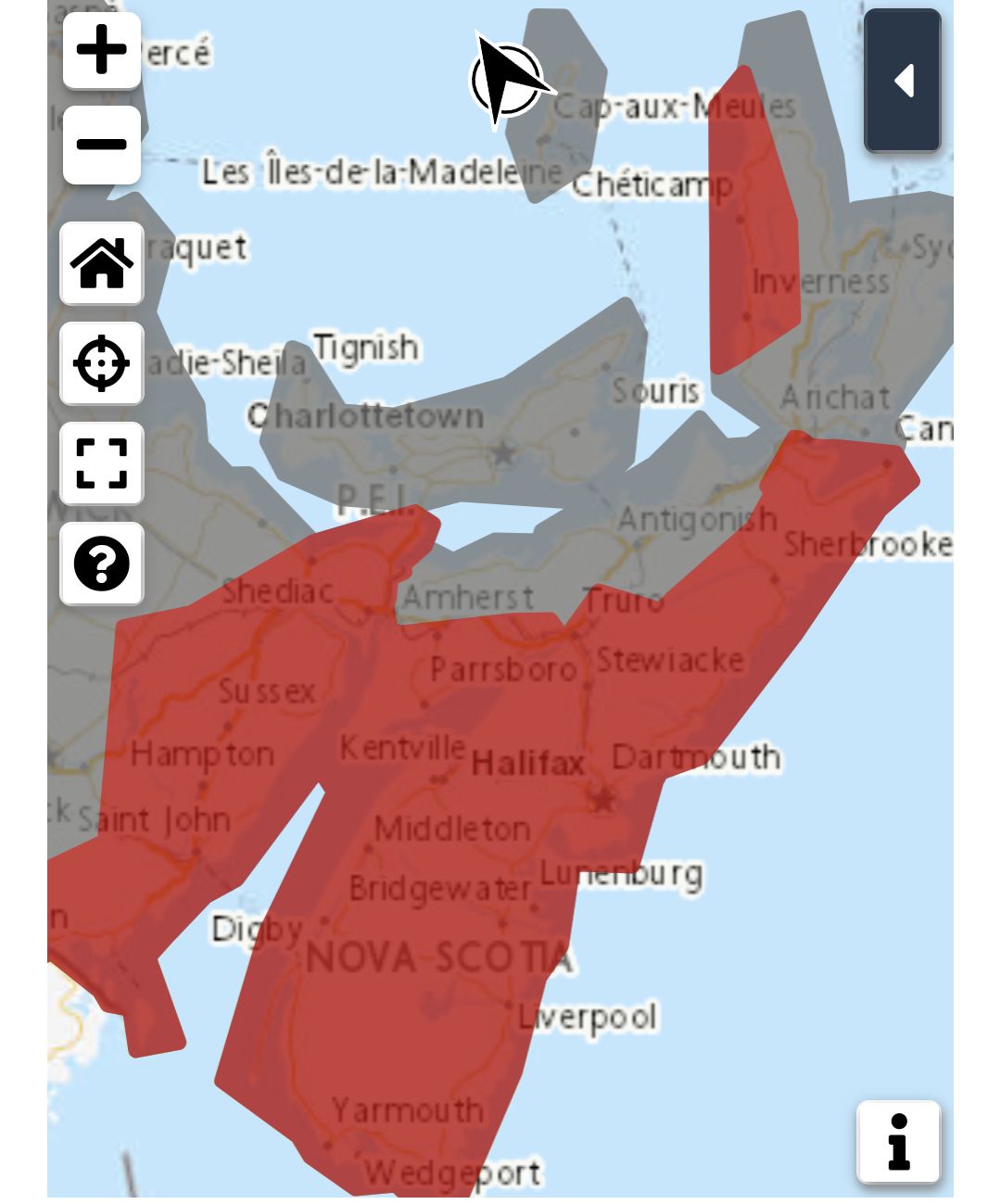
**** Info via Environment Canada
—- Updated
Multiple warnings and statements in relation to Hurricane Lee in effect

Wind warning
Strong winds that may cause damage are expected or occurring.
Maximum gusts: easterly 90 to 110 km/h.
Locations: western, central and portions of eastern mainland Nova Scotia.
Time span: Saturday.
Damage to buildings, such as to roof shingles and windows, may occur. High winds may result in power outages and fallen tree branches.
Wind warnings are issued when there is a significant risk of damaging winds.
.
Tropical Storm Warning
Tropical storm force winds of 70 gusting to 100 km/h over exposed areas from Hurricane Lee can be expected over the above regions.
Tropical storm conditions expected to begin early Saturday morning.
Corresponding wind, rainfall, and storm surge warnings will be issued for affected areas later today.
These winds could break tree branches potentially resulting in downed utility lines.
Secure loose objects on your property and anticipate power interruptions. Stay away from the shore – the combination of surge and large waves could result in dangerous rip currents and the risk of being pulled out to sea.
By nature, a tropical storm also implies the threat of local flooding from heavy rainfall – consult your local area forecast for possible rainfall warnings.
Please continue to monitor alerts issued by the Canadian Hurricane Centre and forecasts issued by Environment Canada. Reports of storm conditions and impacts can be emailed directly to [email protected] or by tweeting reports by province using #NSStorm, #NBStorm, #PEStorm, #NLwx, #QCStorm or #ONStorm.
.
Storm Surge Warning
Storm surge warnings are issued when water levels pose a threat to coastal regions.
.
Tropical Cyclone statement
The next information statement will be issued at 9:00 a.m. ADT.
Hurricane Lee will be moving into western Nova Scotia / southern New Brunswick Saturday with heavy rains, high winds, and large waves, then weakening quickly Saturday night with lingering conditions on Sunday.
Intensity/classification: Category-1 hurricane becoming a strong tropical storm then transforming into post-tropical low while making landfall anywhere from Grand Manan Island New Brunswick to Shelburne County Nova Scotia Saturday evening.
1. Summary of basic information at 3:00 a.m. ADT.
Location: 33.5 degrees North 67.8 degrees West.
About 318 km west-northwest of Bermuda.
Maximum sustained winds: 139 kilometres per hour.
Present movement: North around 28 kilometres per hour.
Minimum central pressure: 957 millibars.
2. Public weather impacts and warnings summary.
A Hurricane Watch is in effect for Grand Manan and Coastal Charlotte County in New Brunswick and Digby, Yarmouth, Shelburne, and Queens Counties in Nova Scotia.
A Tropical Storm Warning is in effect for the New Brunswick Fundy Coast. Most of mainland Nova Scotia is now under a Tropical Storm Warning except northern Nova Scotia and Colchester County north and south of Truro.
The circulation of Hurricane Lee will be quite broad as it reaches our region so impacts will occur not only near the track but up to 300 km away from it.
a. Wind.
Most likely region for worst impacts: western Nova Scotia as well as Grand Manan and Coastal Charlotte County region of New Brunswick. Areas under the tropical storm warning could see sustained winds of 70 km/h with gusts of 90 to 100 km/h possible. Areas under the hurricane watch will likely see the strongest winds, with potential gusts of 120 km/h. These winds would typically result in some tree damage and utility interruptions.
b. Rainfall.
Heaviest rainfall threat has shifted eastward a bit and now runs through central New Brunswick and northward into the Gaspe region and the Quebec Lower North Shore out to Blanc-Sablon. The risk of heavy rains is decreasing (but still exists) for the Rimouski and Temiscouata area.
Rainfall totals in excess of 100 mm are possible, especially in areas to the left of the track. NOTE: Western Nova Scotia and the Annapolis Valley flooding risk has increased – there could be heavy amounts in the vicinity of the track itself with indications of possibly 75 mm directly from Lee. This combined with the rain that fell there Thursday increases the vulnerability to further flooding in that area.
c. Surge/Waves.
High waves and elevated water levels will be widespread due to the large size of the storm – the most impacted areas likely covering much of the Atlantic coast of mainland Nova Scotia and to a much lesser extent, the Fundy coast of New Brunswick. Wave conditions could also become rough in areas in the southwestern Gulf of St Lawrence / western Northumberland Strait but should remain below warning criteria.
For Atlantic coastal Nova Scotia breaking waves of 4-6 metres (15 to 20 feet) are likely. Elevated water levels (storm surge) combined with waves could result in coastal flooding during the high tide late morning to noon Saturday in Shelburne County then during the high tide late Saturday evening along the coast from Queens County to eastern Halifax County. It is during this late-Saturday period where a storm surge warning may be required – water levels up to 1 metre (3 feet) above high tide is possible. Consider this statement effectively as a ‘watch’.
3. Marine weather impacts and warnings summary.
Greatest waves and winds expected around the Bay of Fundy, Gulf of Maine and southwest Maritimes marine district. Hurricane force wind warnings are in effect for southwestern waters near the track. Storm or gale warnings are in effect for most remaining waters.
Please continue to monitor alerts issued by the Canadian Hurricane Centre and forecasts issued by Environment Canada.
weather.gc.ca/hurricane/statements_e.html
Source
https://weather.gc.ca/?province=ns&zoom=6¢er=45.67357216,-63.57817878


