**** Info via Environment Canada
ENDED
Tropical cyclone information statement for:
New Brunswick
Nova Scotia
Prince Edward Island
For Tropical Storm Elsa.
Updated July 9

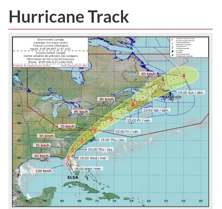
Tropical Storm Elsa is picking up speed as it moves into Delaware and south of New Jersey this morning. Elsa is expected to track across the Maritimes as a Post-Tropical storm late this evening into Saturday bringing significant rain and some gusty winds to parts of the region.
1. Summary of basic information at 03:00 a.m. ADT.
Location: Near 38.4 North 75.5 West.
About 140 kilometres southwest of Atlantic City, NJ.
Maximum sustained winds: 85 kilometres per hour.
Present movement: Northeast at 40 kilometres per hour.
Minimum central pressure: 1002 millibars.
2. Public weather impacts and warnings summary.
Elsa is expected to maintain intensity as it continues to move along the mid-Altantic coast of the US and towards the Maritimes by late this evening. Significant rainfall is likely ahead of Elsa associated with a trough moving in from southern Quebec today, along with additional rainfall tonight into Saturday with the passage of Elsa.
a. Wind.
Widespread damaging winds from Elsa are not expected across the Maritimes at this time. However some gusty winds are possible south and east of its track through the region, potentially gusting to 60 or 70 km/h with brief gusts possible to 80 km/h over southwestern New Brunswick and western Nova Scotia tonight.
b. Rainfall.
Rainfall warnings have been issued for all of New Brunswick and Prince County PEI. Areas along and north of Elsa’s track through the region will pick up significant rainfall. Most model guidance is indicating potentially 50-100 mm of total rainfall over parts of New Brunswick into Saturday morning.
c. Surge/Waves.
No significant coastal impacts from storm surge is currently expected from Elsa. Latest wave models suggest wave heights of 2 to 3 metres reaching the Atlantic Coast of Nova Scotia by late tonight into Saturday.
3. Marine weather impacts and warnings summary.
Gale warnings are in effect for western marine areas. Strong to gale force winds are likely in some waters just south and east of Elsa’s track tonight into early Saturday morning. Offshore waves of near 4 metres are possible over the western Maritime marine district late this evening.
Forecaster(s): McArthur
Please continue to monitor alerts issued by the Canadian Hurricane Centre and forecasts issued by Environment Canada.
For more comprehensive information about track tables and forecast rationale, please see the Technical Discussion
Visit the Canadian Hurricane Centre to learn more about hurricanes.
.
The next information statement will be issued by 03:00 p.m. ADT.
Tropical Storm Elsa is currently near the Gulf coast of Florida. Elsa is expected to track across the Maritimes as a Post-Tropical storm early this weekend bringing significant rain to parts of the region.
1. Summary of basic information at 09:00 a.m. ADT.
Location: Near 29.2 North 83.6 West.
About 170 kilometres northwest of Tampa FL.
Maximum sustained winds: 100 kilometres per hour.
Present movement: North at 22 kilometres per hour.
Minimum central pressure: 999 millibars.
2. Public weather impacts and warnings summary.
As Tropical Storm Elsa is still several days away from affecting our region, specific details on its impacts in our region are preliminary at this time. These impacts could change significantly depending on how the storm evolves over the next few days as it traverses the southeastern United States.
a. Wind.
Widespread damaging winds from Elsa are not expected across the Maritimes at this time. However some gusty winds are possible just south of its eventual track through the region, potentially gusting to 60 or 70 km/h.
b. Rainfall.
The most likely impact from Elsa will be rainfall, with areas along and north of its eventual track through the region picking up significant rainfall, likely in excess of 50 mm.
c. Surge/Waves.
No significant coastal impacts from storm surge or high waves is currently expected from Elsa.
3. Marine weather impacts and warnings summary.
Gale force winds are possible in some waters just south of Elsa’s track on Friday or early Saturday.
Forecaster(s): Borgel
Please continue to monitor alerts issued by the Canadian Hurricane Centre and forecasts issued by Environment Canada.
For more comprehensive information about track tables and forecast rationale, please see the Technical Discussion
Visit the Canadian Hurricane Centre to learn more about hurricanes.