**** Info via Environment Canada
Canada’s unprecedented wildfire season
As of July 20, a staggering 11.1 million hectares of forest area has burned in Canada – an area roughly the size of the island of Newfoundland – with several weeks of peak wildfire season to go.
The previous national record for area burned was set in 1989 (the record began in 1983) when 7.6 million hectares of wildland burned. This year, that number was surpassed on June 27, following weeks of intense-burning wildfires from coast to coast. In a typical year, Canada sees about 2.1 million hectares burned by the end of the season.
Year-to-date burned area in 2023 in comparison with past years as of July 19 across Canada. Source: Canadian Interagency Forest Fire Inc.
The first significant wildfires of 2023 occurred in Alberta, Saskatchewan, the Northwest Territories and northern British Columbia in May, following the first of several prolonged heat waves bringing record-breaking temperatures to many areas. In June, activity shifted east to include northern Quebec, resulting in widespread smoke that darkened the skies and reduced air quality for millions across eastern North America.
Map of current active fires on July 21. Source: Canadian Wildland Fire Information System, Natural Resources Canada.
The wildfires have so far led to the evacuation of over 120,000 Canadians and contributed to the deaths of two wildland firefighters, with some fires in remote areas across the country growing very large. The intense burning conditions have brought about intense fire behaviour that has been extremely challenging for ground crews to manage, with help coming into the country from such far-flung locations as Brazil, Costa Rica, and South Africa.
Drought and lightning are major factors
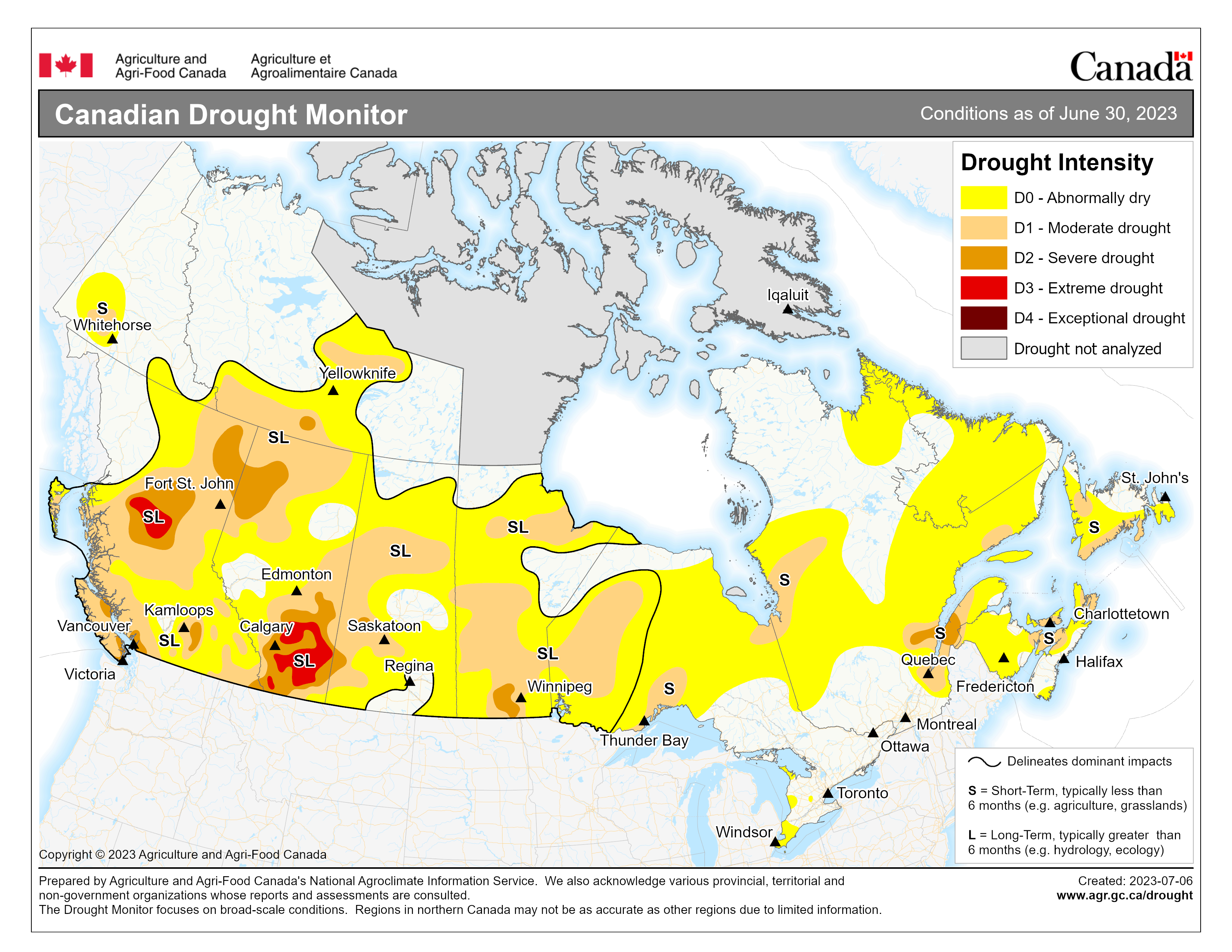
Widespread drought impacts many areas of Canada, which, when combined with hot, dry, and windy weather, contributes to the severity of fire behaviour and ease of ignition in some regions. Drought is particularly severe in portions of central British Columbia and the northern Prairie Provinces and may continue in the coming months, raising concerns that fires could burn well into fall while setting up 2024 for an early and challenging start to wildfire season.

Canadian drought map shows the extent and severity of drought conditions across Canada. The scale used runs from D0 Abnormally dry to D4 Exceptional drought. Source: Agriculture and Agri-Food Canada.
Lightning has also been the source of ignition for many wildfires this season. Of note, a rash of lightning strikes on June 1 across northern Quebec resulted in numerous wildfire ignitions that quickly intensified with prime fire weather conditions in the following days. While about 50% of all wildfire ignitions in Canada are typically the result of lightning, lightning-caused fires are responsible for 80-90% of the area burned due to their occurrence in remote areas.
For more information on how to better prepare for a wildfire event: Wildfires – Get Prepared.


